
Betsy Ross Bridge
Coordinates: 39 ° 59 ′ 9 ″ N , 75 ° 4 ′ 0 ″ W.
| Betsy Ross Bridge | ||
|---|---|---|
 |
||
| use |
|
|
| Crossing of | Delaware River | |
| place | Bridesburg ( Philadelphia ), PA and Pennsauken Township , NJ | |
| Entertained by | Delaware River Port Authority | |
| construction | Truss bridge | |
| overall length | 2,586 m | |
| width | 32 m | |
| Longest span | 222 m | |
| Clear height | 41 m | |
| building-costs | 103 million US dollars | |
| start of building | 1969 | |
| completion | 1974 | |
| opening | 1976 | |
| location | ||
|
||

The Betsy Ross Bridge is a six-lane road bridge over the Delaware River between the northeastern Bridesburg neighborhood of Philadelphia in Pennsylvania and Pennsauken Township in New Jersey . It runs along New Jersey Route 90 , which is connected to Interstate 95 in Pennsylvania and US Highway 130 in New Jersey . The bridge is operated by the Delaware River Port Authority and is toll road going west into Philadelphia . The average traffic volume is around 45,000 vehicles per day. The bridge is named after Betsy Ross, who, according to legend, allegedly sewed the first flag of the United States in 1776 , which is now in doubt.
history
The bridge was planned in the 1950s as an alternative river crossing to the upstream Tacony-Palmyra Bridge in the northeastern part of Philadelphia . This road bridge from 1929 has only three lanes for vehicle traffic, which must be interrupted for shipping by opening an integrated bascule bridge . In addition, the United States Army Corps of Engineers viewed the bridge as a major obstacle to navigation on the river section. The Betsy Ross Bridge was finally built from 1969 as an additional bridge in the immediate vicinity of the Delair Bridge , a railway lift bridge from 1896, roughly halfway between the Tacony-Palmyra Bridge and the Benjamin Franklin Bridge . The construction work was completed five years later (1974), but due to opposition from residents of the Bridesburg district, supported by high-ranking politicians, the completion of the driveways and thus the opening ceremony, which was accompanied by protest rallies on the Pennsylvania side, was delayed until April 30, 1976.
The payment of the fees for the use in the west to Philadelphia takes place at a toll station in front of the entrance in Pennsauken, the opposite direction is toll free. The electronic toll system E-ZPass was introduced at the end of 1999. As part of renovation work, the configuration with eight lanes was changed in 2000 and the number was reduced to six wider lanes. On the Philadelphia side, New Jersey Route 90 forms a triangle with Interstate 95 in front of the access to the bridge . Two unfinished ramps just before I-95 still bear witness to the years of wrestling with the residents of Bridesburg over the route of the access roads.

Aerial views of the Betsy Ross Bridge and the neighboring Delair Bridge (2015)

Above the entrance in Philadelphia behind the interstate with the I-95 , below the toll station in New Jersey (2012)


description
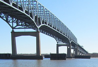
The central element of the steel - Cantilever Bridge is a 444 m long and 32 m wide symmetrical truss with bottom surfaces. It is designed as a continuous continuous beam with a span of 222 m between the central river pillars and 111 m long cantilever arms . This is followed by five shorter lattice girders with an overhead carriageway on each side, followed by several girder bridges for the driveways, the number of which adds up to a total of 41. The bridge has a total length of 2,586 m between the abutments and consists of a total of 29,326 tons of steel. The carriageway is 27.4 m wide and offers space for three lanes in each direction of travel, which are separated from each other by a concrete protective wall.
For shipping traffic, a clear width of around 120 m between the central river pillars has been implemented below the continuous girder, with a clear height of 41 m (based on the mean flood ) and a minimum depth of the fairway of 12 m.

Driveway to the six-lane bridge (2014)
Continuous girders over the fairway, central river pillars with ship deflectors (2012)


Web links
- Betsy Ross Bridge. Delaware River Port Authority.
Individual evidence
- ↑ a b c Betsy Ross Bridge (NJ 90) - Historic Overview. PhillyRoads.com from Eastern Roads, Inc. Retrieved January 10, 2018.
- ^ A b Steven M. Richman: The Bridges of New Jersey: Portraits of Garden State Crossings. Rutgers University Press, 2005, ISBN 978-0813537825 , pp. 88-90.
- ↑ a b Betsy Ross Bridge. ( Memento of February 25, 2018 on the Internet Archive ) Delaware River Port Authority.
|
Upstream Tacony – Palmyra Bridge |
Crossing the Delaware River |
Downstream Delair Bridge |