
Illustration of the road signs in Denmark
The picture table of the road signs in Denmark shows a selection of important road signs in Denmark . They are regulated in the samlet oversigt over varianter af færdselstavler, vejvisningstavler including kant- og baggrundsafmærkninger .
A: warning signs
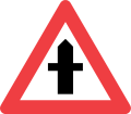
A11: right of way at intersections

A12.1: Right of way at junctions
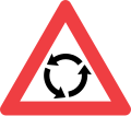
A16: roundabout
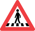
A17: pedestrian crossing

A18: two-way traffic
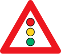
A19: traffic light system

A20: traffic jam

A21: cyclists
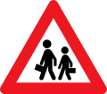
A22: children
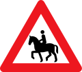
A23: rider

A26: Deer crossing

A27: cattle drive
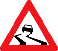
A31: Risk of skidding

A33: grit, gravel
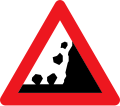
A34: Rockfall

A35: Side heel
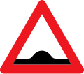
A36: speed bump
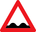
A37: uneven road surface

A39: construction site

A41.1: curve (right)

A41.2: curve (left)
A42.1: double curve (initially on the right)

A42.2: double curve (initially left)

A43.1: Narrow roadway

A43.2: Road narrowed on one side (left)
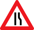
A43.3: Roadway narrowed on one side (right)

A44: tunnel
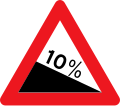
A46.1: slope
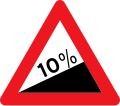
A46.2: incline

A71: tram

A72: Unrestricted level crossing

A73: Gated level crossing

A74.1: Single- track level crossing

A74.2: Multi- track level crossing

A75: Distance beacons

A91: Movable Bridge

A92: shore

A95: cross wind

A96: Flight operations (aircraft)

A97: flight operations (helicopter)

A99: Other dangers


B: precedence sign

B11: Give way

B11: give right of way in 500 meters

B11: Stop in 200 meters

B13: Stop

B15: junction

B16: priority road

B17: end of the priority road

B18: Give oncoming traffic priority

B19: Priority over oncoming traffic


C: Prohibition sign

C11.1: No right turns
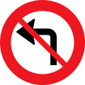
C11.2: No left turns

C12: No U-turn
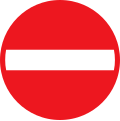
C19: No entry

C21: No passage

C22.1: No entry for motor vehicles, mopeds, tractors and agricultural machinery

C22.2: No entry for motorcycles

C23.1: No entry for trucks

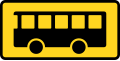
C23.2: No entry for buses and coaches

C23.3: No entry for vehicles with dangerous goods

C24.1: No entry for tractors and agricultural machinery

C24.2: No entry for wagons
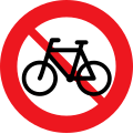
C25.1: No entry for bicycles and mopeds
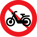
C25.2: No entry for mopeds

C26.1: No entry for riders
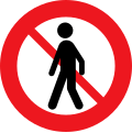
C26.2: No entry for pedestrians

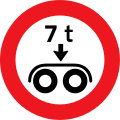
C31: Prohibition for vehicles over specified actual weight

C32: Prohibition on trains over the specified weight including cargo

C35: Prohibition for vehicles over stated actual axle load
C36: Prohibition for vehicles with a specified actual tandem axle load
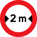
C41: Prohibition for vehicles over specified width including load

C42: Prohibition for vehicles over specified height including load
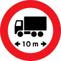
C43: Prohibition on vehicles over specified length including load
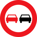
C51: No overtaking for all types of vehicles
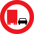
C52: No overtaking for trucks
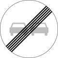
C53: End of the overtaking ban for all types of vehicles

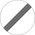
C54: End of the overtaking ban for trucks
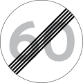
C56: End of the permitted maximum speed
C59: End of all route bans
C92: Hold for the stated purpose


D: mandatory sign
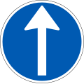
D11.1: Prescribed driving direction - straight ahead

D11.2: Prescribed driving direction - here on the left

D11.3: Prescribed driving direction - here on the right
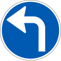
D11.4: Prescribed direction of travel - left

D11.5: Prescribed driving direction - right

D11.6: Prescribed driving direction - straight ahead and left

D11.7: Prescribed direction of travel - straight ahead and right

D11.8: Prescribed driving direction - left and right

D12: roundabout
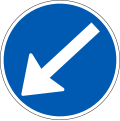
D15.2: Mandatory drive by - turn left
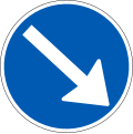
D15.3: Prescribed pass - right past

D16: Mandatory drive by - left and right past
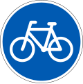
D21: cycle path
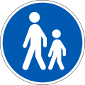
D22: sidewalk
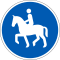
D23: bridle path
D26: Separate walkway and bike path (walkway left, bike path right)

D26.1: Separate bridle path and sidewalk (sidewalk left, bridle path right)

D26.2: Separate footpath and cycle path (cycle path on the left, walkway on the right)
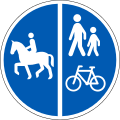
D26.3: Separate riding, walking and cycling path (bridle path on the left, cycling and walking path on the right)

D26.4: Separate riding, walking and cycling path (bike and walking path on the left, bridle path on the right)

D26.5: Separate bridle path and walkway (bridle path on the left, walkway on the right)

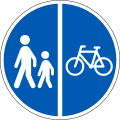
D27: Common footpath and bike path

D27.1: Common riding, walking and cycling path

D56: End of the prescribed minimum speed


E: Notice symbol

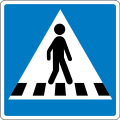
E17: pedestrian crossing (right)
E17.1: pedestrian crossing (left)

E18: dead end

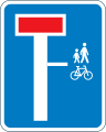
E18.1.1: Permeable cul-de-sac for pedestrians and cyclists
E18.1.2: Dead end with a street on the right that is open for pedestrians and cyclists

E18.1.3: Dead-end street with a continuous street on the left for pedestrians and cyclists

E19: one-way street

E21.1: Recommended route for cyclists

E21.2: Recommended route for pedestrians

E21.3: Recommended route for riders

E21.4: Recommended route for mopeds

E22.1: Recommended route for trucks
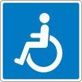
E23: the physically handicapped

E24: the visually impaired

E26.1: pedestrian overpass

E30: tram stop
E31: bus stop
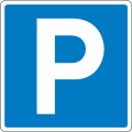
E33.1: parking lot

E33.2: Parking garage

E34: emergency bay

E39: recommended speed

E40: End of recommended speed

E42: motorway

E43: Motorway
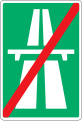
E44: end of the motorway
E45: end of the road
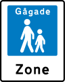
E49: pedestrian zone

E50: end of the pedestrian zone
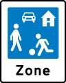
E51: traffic-calmed area

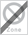
E52: End of the restricted traffic area

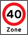
E53: Area with speed reduction

E55: start of the village
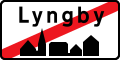
E56: end of town
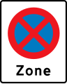
E68.2: Beginning of an area with an absolute no-stopping zone
E68.4: Beginning of a range with maximum permissible speed
E69: End of a restricted parking area

E69.3: End of a parking zone
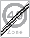
E69.4: End of a range with maximum permissible speed

E69.5: End of a no-entry area for trucks
E80: General maximum speeds

E90: Automatic speed monitoring


Q: Signposting

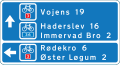
F11: Arrow signpost on non-motorways

F12: arrow signs to the motorway

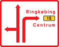
F13: Arrow signposts to inner-city facilities with significant traffic significance

F14: Arrow sign pointing to a temporary event

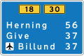
F18: Table guide

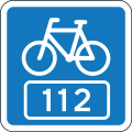
F21.1: National cycle route
F21.1.1: Regional or local cycle route

F21.1.2: hiking trail

F21.1.3: bridle path

F21.2: arrow signposts on cycle paths

F21.2.2: arrow signs on hiking trails

F21.2.3: Arrow signs on bridle paths
F21.3: Table signposts on cycle paths
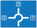
F21.4: Orientation board for roundabouts on cycle paths

F30: Special service guide

F33.2: Table signpost for parking spaces


G: orientation mark

G14: Orientation board for roundabouts
G15: Orientation board with lane division

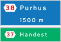
G18: Orientation table in tabular form


H: information sign
H41: Mileage board on non-motorways

H49: National Park

H50: End of National Park

H51: Schengen border


I: Orientation signs (motorway)
I13: Orientation board on the motorway

L: street numbers

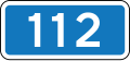
L41: Europastrasse

L42: primary route

L43: secondary route
L44: ring road
L45: National cycle route
L45.2: Regional or local cycle route

L50: tourist road


M: service mark
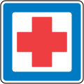
M21: first aid

U: additional character

UA22.1: school

UA31: slippery ice
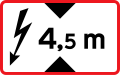
UA73: high voltage
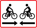
UB11.2: cyclists


Other road signs

Moose

Historic traffic signs
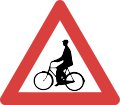
A21: cyclists
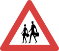
A22: children
A99: Other dangers
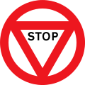
B13: Stop
C51: No overtaking for all types of vehicles
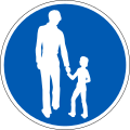
D22: sidewalk
Be careful
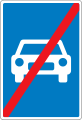
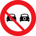
Ban on motor vehicles of all kinds
Railroad Crossing

crossing
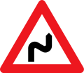
Double curve
.svg)
.svg)
.svg)
.svg)
.svg)
.svg)


Web links
- Catalog of Danish traffic signs (Danish)
Albania | Belgium | Bulgaria | Denmark | Germany ( since 2017 ) | Estonia | Finland | France | Greece | Ireland | Iceland | Italy | Croatia | Latvia | Liechtenstein ( since 2016 ) | Lithuania | Luxembourg | Malta | Moldova | Netherlands | Norway | Austria | Poland | Portugal | Romania | Russia | Sweden | Switzerland ( since 2016 ) | Serbia | Slovakia | Slovenia | Spain | Czech Republic | Ukraine | Hungary | United Kingdom | Belarus | Cyprus