
Bitterbach Gorge
| Bitterbach Gorge | ||
|---|---|---|
 Bitterbach Gorge |
||
| location | District of Nürnberger Land , Bavaria | |
| Waters | Bitterbach | |
| Mountains | Franconian Alb | |
| Geographical location | 49 ° 31 '10 " N , 11 ° 15' 36" E | |
|
||
| Type | canyon | |
| rock | Castle sandstone | |
| particularities | Protected landscape component | |

The Bitterbach Gorge is located in the northwest of the urban area of Lauf an der Pegnitz in the Middle Franconian district of Nürnberger Land in Bavaria . It is a gorge cut into the castle sandstone by the Bitterbach , which runs through a narrow piece of forest here . In dry years such as B. 2018 and 2019 the Bitterbach dries up.
location
The Bitterbach Gorge begins on Brunnenweg in the Rudolfshof district of Lauf , follows the course of the Bitterbach in a south-southeast direction and ends at the Am Bitterbach road in the Kotzenhof district .
description
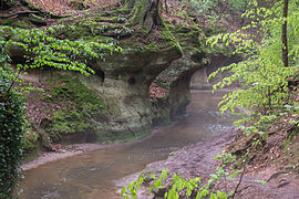
When the cold and warm periods alternated during the Ice Age ( Diluvium ), an epigenetic valley was formed here in which the stream created a new water channel next to its older river bed. During the cold periods with little water flow, the brook deposited large amounts of sand in the old bed and the water flowed over it as a meandering trickle that formed loops. When the climate changed again and it got warmer and more humid, the Bitterbach swelled up again. In doing so, however, he could no longer find his way into his old channel, but instead moved eastwards. He could no longer flow around some crests of reddish, coarse-grained Burg sandstone, so he had to cut through them. The narrow Bitterbach Gorge was created in the hard rock by the erosion force of the flowing water.
In the Bitterbach Gorge there are delightful castle sandstone outcrops and cuts, steep, partly undermined gorge walls, magnificent rocks overgrown with mosses and ferns, deep crevices and holes as well as small waterfalls. Otherwise, the castle sandstone rarely shows good outcrops in the area, it is usually more than 10 meters below the surface of the earth. The gorge running in it is therefore something special. The rock cellars under the old town of Lauf are carved into this castle sandstone.
The gorge is designated as a protected landscape component.

Nature trail
The picturesque incision was opened to the public in the early 1950s. The marked path along the stream is part of the geo-ecological nature trail Bitterbachschlucht . At 27 locations, boards along the way provide information about the importance of the forest for people, the relationships within the forest community, the formation of the Bitterbach Gorge and the threat to the natural balance. In addition, communities of native plants and animals at the stream, at the pond, in the quarry forest and a still preserved hutanger are presented.
Picture gallery
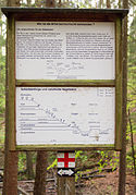
Information board nature trail
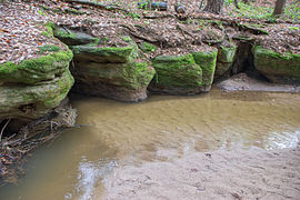
Red sandstone outcrop
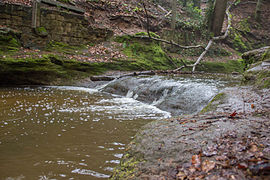
waterfall
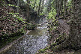
Hiking trail in the valley
Red sandstone outcrop

Trail marking in the gorge


Individual evidence
- ↑ Location of the Bitterbach Gorge in the Bavaria Atlas (accessed on July 7, 2015)
- ↑ Sign on the geo-ecological nature trail Bitterbachschlucht
- ↑ landkreis.nuernberger-land.de, Bitterbachschlucht (accessed on December 17, 2015)
- ↑ Lauf.de: Geo-ecological nature trail Bitterbachschlucht (accessed on July 7, 2015)