Blenhorster Bach
| Blenhorster Bach | ||
|
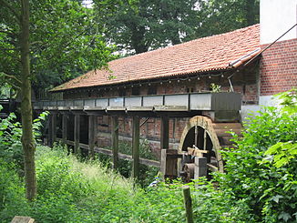
Watermill at Blenhorster Bach |
||
| Data | ||
| location | Balge municipality , Nienburg district , Lower Saxony , Germany | |
| River system | Weser | |
| Drain over | Weser → North Sea | |
| source | southwest of Bötenberg 52 ° 40 ′ 53 ″ N , 9 ° 5 ′ 24 ″ E |
|
| Source height | 73 m above sea level NN | |
| muzzle | at Sebbenhausen in the lock canal Coordinates: 52 ° 43 '53 " N , 9 ° 11' 35" E 52 ° 43 '53 " N , 9 ° 11' 35" E |
|
| Mouth height | 20 m | |
| Height difference | 53 m | |
| Bottom slope | about 4.1 ‰ | |
| length | about 13 km | |
| Left tributaries | Kreuzbach, Wurmgraben | |
The Blenhorster Bach is an approximately 13 km long left tributary of the Weser . It flows exclusively in the area of the Lower Saxony district of Nienburg and there largely in the municipality of Balge .
The Blenhorst watermill, built in 1769, is located on the road from Wietzen to Buchhorst at the Blenhorster Bach. It served as a sawmill and a grinding mill and has two water wheels, one under and one overshot.
course
The Blenhorster Bach rises southwest of Bötenberg , west of the B 6 . From there it flows in a north-easterly direction through Möhlenhalenbeck and Blenhorst . There he takes up the Kreuzbach and then the worm ditch . It flows through Sebbenhausen and flows into the lock canal on the eastern outskirts of Sebbenhausen . This flows into the Weser about 200 m further north.
Web links
- Experience nature in Lower Saxony - Nienburg district
Individual evidence
- ↑ Mühlenstrasse working group in the Mühlenvereinigung Niedersachsen-Bremen eV: Wassermühle Blenhorst
