Bloomfield (Connecticut)
| Bloomfield | ||
|---|---|---|
|
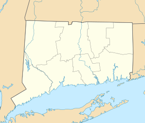
Location in Connecticut
|
||
| Basic data | ||
| Foundation : | 1835 | |
| State : | United States | |
| State : | Connecticut | |
| County : | Hartford County | |
| Coordinates : | 41 ° 50 ′ N , 72 ° 44 ′ W | |
| Time zone : | Eastern ( UTC − 5 / −4 ) | |
| Residents : | 20,696 (as of 2009) | |
| Population density : | 307.1 inhabitants per km 2 | |
| Area : | 67.8 km 2 (approx. 26 mi 2 ) of which 67.4 km 2 (approx. 26 mi 2 ) is land |
|
| Height : | 42 m | |
| Postal code : | 06002 | |
| Area code : | +1 860 | |
| FIPS : | 09-05910 | |
| GNIS ID : | 0213392 | |
| Website : | www.bloomfieldct.org | |
| Mayor : | Louie Chapman, Jr. | |
Bloomfield is a city in Hartford County in the state of Connecticut in the United States .
history
The city was officially founded in 1835, but its roots go back to 1640. In the year it was founded, the city had more than 900 inhabitants.
Parks
Penwood State Park is a 3.2 km 2 park in the north of the city. The park was given to the city as a gift in 1944 by industrialist Curtis Hussey Veeder (1862–1943). Lake Louise in the park was named after his wife.
Economy and Infrastructure
Companies
Bloomfield is the seat of the Kaman Corporation, which is now primarily active in the aviation industry.
traffic
The closest airport is Hartford Airport , which is just north of the city. The city is served by Interstate 91 and Interstate 84 (West) .
Personalities
sons and daughters of the town
- Edward H. Gillette , politician
- Jimmy Greene , jazz musician
- Anika Noni Rose , actress and singer
Personalities who have worked on site
- Joseph F. Ryter , politician
Web links
Commons : Bloomfield, Connecticut - collection of images, videos, and audio files
