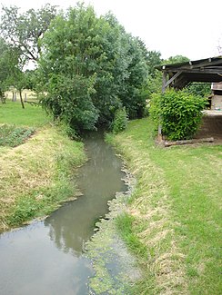
Boderonne
| Boderonne | ||
|
The Boderonne in Villy-en-Trodes |
||
| Data | ||
| Water code | FR : F0820600 | |
| location | France , Grand Est region | |
| River system | His | |
| Drain over | Barse → Seine → English Channel | |
| source | in the municipality of Beurey 48 ° 10 '59 " N , 4 ° 27' 9" O |
|
| Source height | approx. 203 m | |
| muzzle | in the municipality of Montreuil-sur-Barse in the Barse coordinates: 48 ° 13 ′ 37 ″ N , 4 ° 17 ′ 58 ″ E 48 ° 13 ′ 37 ″ N , 4 ° 17 ′ 58 ″ E |
|
| Mouth height | approx. 123 m | |
| Height difference | approx. 80 m | |
| Bottom slope | approx. 4 ‰ | |
| length | approx. 20 km | |
The Boderonne is a river in France that runs in the Aube department in the Grand Est region . It rises in the municipal area of Beurey under the name Val Binet , drains in the upper reaches in an arc from north to southwest, then swings abruptly to north to northwest and after around 20 kilometers flows into the Barse as a left tributary in the municipality of Montreuil-sur- Barse . In its mouth section, it flows through the Forêt d'Orient Regional Nature Park .
Alternatively, the source is also described in Villers , in the municipality of Magnant ( 48 ° 10 ′ 41 ″ N , 4 ° 24 ′ 18 ″ E ).
Places on the river
(Order in flow direction)
