
Bogenberg (mountain)
| Bogenberg | ||
|---|---|---|
.JPG) View of sand to the south |
||
| height | 432 m above sea level NN | |
| location | Bavaria , Germany | |
| Mountains | Bavarian forest | |
| Dominance | 4.37 km → Lintach (Hunderdorf) | |
| Notch height | 87 m ↓ Breitenweinzier | |
| Coordinates | 48 ° 54 '9 " N , 12 ° 41' 46" E | |
|
||

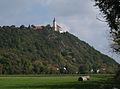
The Bogenberg is a 432 m high mountain on the Danube rim near the town of Bogen and a nature reserve.
It is located east of the town of Bogen and towers over the Danube Valley by around 110 meters. The tower of the Bogenberg pilgrimage church rises from afar on the summit plateau . Hence the nickname Holy Mountain of Lower Bavaria . The slope to the Danube in the south drops steeply and is one of the 100 most beautiful geotopes in Bavaria . There you will find strangely broken and rubbed rocks that build up almost the entire striking mountain. The Way of the Cross stretches up the steep western slope from the city to the pilgrimage church. The northern slope has the lowest incline and is mainly used as a training area for the Graf Aswin barracks . The extension of the elevation along the Danube is over one kilometer.
The mountain gave its name to the parish village of Bogenberg , a formerly independent municipality that is now part of the town of Bogen.
Bogenberg from Donauinsel "Auf der Wörth"

South slope of the Bogenberg geotope

Path on the steep slope


Web links
Individual evidence
- ↑ Bogenberg S from Bogen. (PDF) Geotope number: 278R005. Bavarian State Office for the Environment, February 6, 2017, accessed on February 1, 2018 .
- ↑ Bavaria's most beautiful geotopes - Bogenberg