Bolívar (Bolivia)
| Bolívar | ||
|---|---|---|
| Basic data | ||
| Residents (state) | 484 pop. (2012 census) | |
| height | 3735 m | |
| Post Code | 03-1501-0100-3001 | |
| Telephone code | (+591) | |
| Coordinates | 17 ° 58 ′ S , 66 ° 32 ′ W | |
|
|
||
| politics | ||
| Department | Cochabamba | |
| province | Bolívar | |
| climate | ||
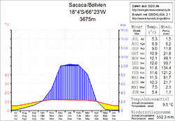
 Climate diagram Sacaca |
||
Bolívar is a town in the department of Cochabamba in the South American Andean state of Bolivia .
Location in the vicinity
Bolívar is the central place and seat of the administration of the province Bolívar and is located at an altitude of 3735 m in the Cordillera Azanaques , a mountain range in the northern part of the Bolivian Cordillera Central . Bolívar is located on the left bank of the Río Carpani, which flows six kilometers further downstream at Yarvicoya into the Río Huaraya.
geography
Bolívar is located between the Bolivian Altiplano in the west and the Cordillera Oriental in the east on the northern foothills of the Cordillera Central .
The region's climate is semi-arid and has a typical time of day climate , in which the mean daily temperature fluctuations are more pronounced than the mean temperature differences over the course of the year.
The annual precipitation is about 550 mm (see climate diagram Sacaca), with a distinct dry season from April to October with less than 20 mm monthly precipitation, and a short wet season in January and February with precipitation well over 100 mm. The mean average temperature of the region is around 9 ° C and fluctuates only slightly between 5 ° C in June / July and 12 ° C in November / December.
Transport network
Bolívar is located in a south-westerly direction 156 kilometers by road from Cochabamba , the capital of the department.
From Cochabamba the paved national road Ruta 4 leads in a westerly direction via the town of Quillacollo to Pongo and on to Caracollo , where it meets Ruta 1 , which crosses the Altiplano from north to south and connects to La Paz , Oruro and Potosí . 8 kilometers after Pongo, a country road branches off to the south, which after 27 kilometers reaches the village of Tacopaya and another 29 kilometers of Bolívar. It continues to Sacaca in the Department of Potosí.
population
The population of the village has increased only slightly in the past two decades:
| year | Residents | source |
|---|---|---|
| 1992 | 420 | census |
| 2001 | 467 | census |
| 2012 | 484 | census |
Individual evidence
- ↑ INE - Instituto Nacional de Estadística Bolivia 1992 ( Memento of the original from April 23, 2014 in the Internet Archive ) Info: The archive link was inserted automatically and has not yet been checked. Please check the original and archive link according to the instructions and then remove this notice.
- ↑ INE - Instituto Nacional de Estadística Bolivia 2001 ( Memento of the original dated December 31, 2015 in the Internet Archive ) Info: The archive link was inserted automatically and has not yet been checked. Please check the original and archive link according to the instructions and then remove this notice.
- ↑ INE - Instituto Nacional de Estadística Bolivia 2012 ( Memento of the original from July 22, 2011 in the Internet Archive ) Info: The archive link has been inserted automatically and has not yet been checked. Please check the original and archive link according to the instructions and then remove this notice.
Web links
- Cochabamba region - Relief map 1: 250,000 (PDF; 10.61 MB)
- Bolívar region - topographic map 1: 100,000 (PDF; 10.78 MB)
- Municipio Bolívar - General Maps No. 31501
- Municipio Bolívar - detailed map and population data (PDF; 374 kB) ( Spanish )
- Departamento Cochabamba - Social data of the municipalities (PDF 7.58 MB) ( Spanish )
