Boragk
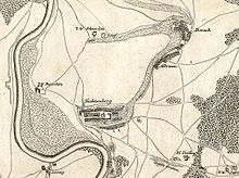
Boragk is part of the Mühlberg district of Altenau . The place is about three kilometers southeast of the city center area and forms the northern part of today's Altenau.
history
First mention and interpretation of the name
Boragk was first mentioned as Borc in a document in 1251 . The name comes from the old Sorbian bor (pine forest). The name Boragk does not appear in this form until around 1443 , which can then be explained with the Sorbian borak (large pine forest).
Local history

In 1251 the village had to pay interest to the Nimbschen monastery . As early as 1345 there was a church in the village, in which the parishes from Altenau, Wendisch-Borschütz, and later also Fichtenberg, Burxdorf and Langenrieth were parish. In 1423 the Nimbschen monastery left the interest income to the Mühlberg monastery. By 1550 there were 31 hooves and 12 possessed men in Boragk . In 1637 the place was destroyed by Swedish troops except for the church.
In 1816 there were 123 inhabitants, in 1925 there were 147 inhabitants and in 1933 there were only 104 inhabitants in Boragk.
On April 1, 1939, the village of Boragk was incorporated into Altenau.
Administrative affiliation
Boragk belonged to the electoral , then to the royal Saxon office of Mühlberg until 1806 and became part of the Liebenwerda district in 1816 . From 1952 the place belonged to the Bad Liebenwerda district , which then became part of the Elbe-Elster district in 1993 .
Culture and sights
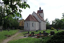
The local village church of Altenau can be found in Boragk with an adjacent cemetery. The church is a late Romanesque brick building from around 1200. The square west tower dates from the 17th century. It has a transverse saddle roof and a slated roof turret. Inside the church there is an organ (op. 109) created around 1893 by the Eilenburg master organ builder Conrad Geißler (1825–1897) . The church also has a large Romanesque font and a pulpit from the 17th century. The building is currently listed in the local list of monuments and is under protection.
There is also a cast iron grave cross and monument protection in the cemetery, the creation of which is dated to the 19th century.
Boragk on a postcard from Meißner Verlag Brück & Sohn (1899)
Web links
Notes and individual references
- ^ Emilia Crome: The place names of the Bad Liebenwerda district. Akademie-Verlag, Berlin 1968, DNB 456303359 .
- ^ O. Bornschein, OF Gandert: Local history for the Liebenwerda district. Verlag C. Ziehlke, Liebenwerda 1929, DNB 572768133 .
- ^ Heinrich Nebelsieck : Stories of the territories and districts of the province of Saxony. Volume 1: History of the Liebenwerda District . Halle an der Saale 1912, OCLC 559872141 .
- ^ Michael Rademacher: German administrative history from the unification of the empire in 1871 to the reunification in 1990. Liebenwerda district. (Online material for the dissertation, Osnabrück 2006).
- ↑ a b Database of the Brandenburg State Office for the Preservation of Monuments and the State Archaeological Museum ( Memento of the original from December 9, 2017 in the Internet Archive ) Info: The archive link has been inserted automatically and has not yet been checked. Please check the original and archive link according to the instructions and then remove this notice. , accessed on September 11, 2017.
- ^ Georg Dehio: Handbook of German Art Monuments - Brandenburg . 2nd Edition. 2012, ISBN 978-3-422-03123-4 , pp. 7-8 .
- ↑ The Boragker village church on the website www.askanier-welten.de , accessed on September 11, 2017.
- ↑ The Boragker or Altenau village church on the homepage of the evangelical parish area Mühlberg / Elbe and Koßdorf , accessed on September 11, 2017
- ↑ Cultural Office of the Elbe-Elster district, Bad Liebenwerda district museum, Sparkasse Elbe-Elster (ed.): Orgellandschaft Elbe-Elster . Herzberg / Elster 2005, p. 60 .
Coordinates: 51 ° 25 ′ 21.1 ″ N , 13 ° 15 ′ 48.6 ″ E


