
Brandkogel
| Brandkogel | ||
|---|---|---|
 Brandkogel from Plangeross |
||
| height | 2676 m above sea level A. | |
| location | Tyrol , Austria | |
| Mountains | Ötztal Alps | |
| Coordinates | 46 ° 58 '31 " N , 10 ° 51' 4" E | |
|
||
| rock | Veteran | |
| First ascent | 1898 by O. Mannskopf, F. Kirschner (from Plangeross) | |

The Brandkogel is a mountain of the Kaunergrat , a mountain range of the Ötztal Alps . The mountain stands directly north of the Rifflsee and is a “first row” mountain when viewed from the Pitztal . It slopes down towards the Pitztal in rocky terraces and is a popular panoramic mountain that is frequently visited. The Cottbuser Höhenweg leads through its eastern flank towards Kaunergrathütte . The Brandkogel is the beginning of a ridge that leads via Zuragkogel and Hoher Kogel to Seekarlesschneid , which delimits the Rifflsee basin to the north.
Routes
The normal route leads from the Rifflsee over the Cottbuser Höhenweg to the eastern flank of the mountain, until a marked trail branches off to the summit of the Brandkogel. On this path (I), which is only recommended for the experienced, you climb over rocky terraces and crags to the top of the summit. Now turn left around the summit block onto the broad west ridge of the Brandkogel and to the summit.

On the west ridge of the Brandkogel. On the opposite side of the valley Hohe Geige (left) and Puitkogel
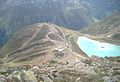
View from the summit to the Rifflsee


literature
- Walter Klier : Alpine Club Guide Ötztaler Alpen , Bergverlag Rudolf Rother, Munich 2006. ISBN 3-7633-1123-8
- Ludwig Obersteiner: Guide through the Ötztal Alps , Reichenstein-Verlag, Vienna 1925