
Puitkogel
| Puitkogel | ||
|---|---|---|
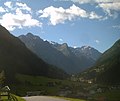
 Puitkogel from the northwest, from Gah winds |
||
| height | 3343 m above sea level A. | |
| location | Tyrol , Austria | |
| Mountains | Ötztal Alps | |
| Dominance | 2.6 km → Hohe Geige | |
| Notch height | 390 m ↓ Weißmaurachjoch | |
| Coordinates | 46 ° 58 '57 " N , 10 ° 53' 59" E | |
|
||
| First ascent | 1858 by farmers from Pitztal | |
| Normal way | South ridge ( II ) | |

The Puitkogel (also Puikogel ) is a mighty, 3343 m above sea level. A. high summit in the Geigenkamm south-east of the Rüsselsheimer Hütte and south-west of the Weißmaurachjoch. Three large ridges descend from the promising rock pyramid. The north-west and south-west ridge pull in two huge rock pillars against the Pitztal, while the east ridge pulls towards Pollestal.
The mountain stands out due to its extremely massive and at the same time high mountain shape. It can be clearly seen in the Pitztal even from the Jerzener Alm. It can also be seen as far as the farthest Taschach valley. In addition to the Hundstalkogel , the Hoher Geige and the Hairlacher Seekopf , it is one of the mountains that dominate the panorama of the Pitztal . Its history of ascent has some interesting details.
Ascent history
The first tourist ascent of the Puitkogel took place in 1879 from Plangeross accompanied by the guide Isaak Dobler, after Pitztal farmers are said to have climbed the top in 1858. On August 22, 1893, Rudolf L. Kusdas , mountain pioneer of the Kaunergrat and Geigenkamm, attempted to climb the Puitkogel from Mittelberg. It had climbed through the Wassertal to the southwest flank of the Puitkogel, but then had to turn back about 100 meters below the summit.
On August 29, 1894, the Innsbruck medical student Fritz Lantscher and the forest warden Franz Gstrein made another attempt to conquer the summit. They hiked into the Pollestal and climbed from the Pollesau to the southern limb of the Puitkogelferner. In a difficult climb they reached a notch east of the summit, in front of the east shoulder of the mountain. They had to overcome a sharp, ice-filled gap in steps and finally reached the summit of the Puitkogel from the southeast. They descended over the blocky south ridge to the Grubenkarlferner, from where they came back to the Pollestal.
On August 29, 1895, Rudolf L. Kusdas, who thought the mountain was still unclimbed, made another attempt to climb it. He climbed from Mittelberg to Pollesjoch and crossed all the mountains of the ridge to the Wassertalkogel . From there he climbed the Sonnenkogel via the Südscharte and crossed it in the direction of the Scharte between Puitkogel and Sonnenkogel. The great difficulties of the ridge forced him over Runsen into the western flank of the ridge. He finally reached the saddle south of the Puitkogel and climbed the mountain over the south ridge, today's normal route.
Routes
Normal route (II): On the Mainzer Höhenweg to the southern Puitkogelferner, from there westwards against the mountain flank up over the ice and over light rock to the east-facing block shoulder of the south ridge. In a steep rubble gully uphill extremely difficult. Steep sections of the channel are avoided or climbed. To the south ridge up into the last notch before the summit. (Variant from the Pitztal): From Mandarfen over a steep path to the grassy slopes of the Mandarfen-Sonnenkogel. As soon as possible, one traverses slightly uphill over steep grass slopes to the north. A run that descends steeply in the direction of Wassertal is traversed at a suitable point. Continue crossing to a steep wall that drops into the uppermost Wassertal. You can overcome it either at the top, directly under the rock face of the Sonnenkogel, or further down through a chimney that descends 10 meters. Now over the uppermost slopes of the water valley to a striking rock channel. Up in the easily passable, steep run. Ignoring the smaller branches of the channel, you get to the gap between Sonnenkogel and Puitkogel. On the often wide, blocky south ridge (II) up to the last notch before the summit.
From the saddle over ledges to the right onto the block ridge and moderately difficult (II) in the eastern ridge flank or directly on the ridge height to the summit.
Northeast ridge (II, partly III): From the Weißmaurachjoch follow the Mainzer Höhenweg to the first, steep, first upswing, which is vertical at the top. In fragile terrain, steeply up to below its top, steepest part. Continue up through a rocky channel and rubble belts and over a crawling belt with an overhanging overhang to the left to a törl. You reach a rock plateau on the other side and climb the upswing (III) over a steep, crack-riddled wall. The following, heavily chipped ridge is first overcome at the edge, overcoming a hanging spot, avoiding a break over a rubble strip on the right and gaining the broad ridge plateau via well-stepped blocks. Over the plateau and some snow fields to narrow the ridge again. Now always on the left side of the edge over slabs and ribbons to the east summit (3278 m) and beyond into a small glacier-filled basin, which forms the last notch before the main summit. From the basin steeply over a block upswing to a pre-summit and on a sharp edge over to the actual summit structure. To the left over inclined plates to a channel and in it up to the main summit.
The mountain is extremely difficult to climb over the two ridges that descend towards the Pitztal. The difficulty of these routes is IV.
Impressions
Hundstalkogel, Hohe Geige, Sturpen and Puitkogel from the lower Pitztal

Puitkogel from the Rifflsee

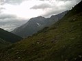
The ridge pillars of the Puitkogel
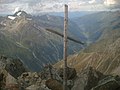
At the summit
Puitkogel from the Taschach valley

Puitkogel from the south

Puitkogel from the north
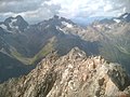
View of the Kaunergrat from the summit


Literature and map
- Walter Klier : Alpine Club Guide Ötztaler Alpen , Bergverlag Rudolf Rother , Munich 2006. ISBN 3-7633-1123-8
- Ludwig Obersteiner: Guide through the Ötztal Alps, Reichenstein Verlag, 1937 (2nd edition)
- Alpine club map sheet 30/5, 1: 25,000, Ötztal Alps, Geigenkamm , ISBN 3-928777-44-0
Web links
Individual evidence
- ^ Journal of the German and Austrian Alpine Association , Volume 37, 1906, p. 277