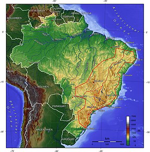
Brazilian mountain country

The Brazilian Highlands is in the east of the South American continent located large landscape . In Brazil , for example, it extends in a north-south direction parallel to the coast and is bounded in the west at around 50 degrees of longitude by the Amazon lowlands , the Pantanal and the southern pampas . It is mostly separated from the Atlantic coast by a steadily rising strip of flat land up to about 300 km wide, on which many metropolises have settled (e.g. Recife , Salvador da Bahia ). Only in the south-eastern part of Brazil does the mountainous region come right up to the coastand leads z. B. in Rio de Janeiro to the pronounced mountainous panoramas with sea (the Corcovado mountain is 710 m high and is only about three kilometers inland).
The Brazilian mountainous region is a highland that has been severely carved out by erosion and is at an average altitude of between 305 and 915 m. There are, in turn, individual mountain ranges such as the Serra do Mar , which reach an average height of 1200 m above sea level. The highest elevation of the Brazilian mountains is found in the southeastern part of Brazil with the Pico da Bandeira (2892 m altitude) in the Serra de Caparaó mountains in the border area between the states of Minas Gerais and Espírito Santo , which is also the third highest elevation in Brazil. The height of the large landscape drops continuously to the north. The average altitude of the plateau of the northeastern state of Pernambuco is around 600 m.
In a south-north direction, the Rio São Francisco flows through almost all of the Brazilian mountains. With a length of 2900 km it is the fourth longest river in South America and the longest river in Brazil outside the Amazon basin. Due to its relief energy , the Brazilian highlands are, in contrast to the Amazon basin, much better suited for damming rivers for the purpose of generating energy. The São Francisco was therefore dammed in two places in its water-rich lower reaches to large reservoirs in order to supply some of the surrounding states and cities (especially Recife and Salvador da Bahia ) with clean energy.
