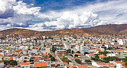
Arcoverde
| Município de Arcoverde "Portal do Sertão"
Arcoverde
|
|||
|---|---|---|---|
|
Panorama, October 2012
|
|||
|
|
|||
| Coordinates | 8 ° 25 ′ S , 37 ° 4 ′ W | ||
 Location of the municipality in the state of Pernambuco Location of the municipality in the state of Pernambuco
|
|||
| Symbols | |||
|
|||
| founding | September 11, 1928 | ||
| Basic data | |||
| Country | Brazil | ||
| State | Pernambuco | ||
| ISO 3166-2 | BR-PE | ||
| height | 663 m | ||
| climate | semiarid, BSh | ||
| surface | 323.4 km² | ||
| Residents | 68,793 (2010) | ||
| density | 212.7 Ew. / km² | ||
| estimate | 73,844 Ew. (July 1, 2018) | ||
| Parish code | IBGE : 2601201 | ||
| Time zone | UTC −3 | ||
| Website | www.arcoverde.pe.gov.br (Brazilian Portuguese) | ||
| politics | |||
| City Prefect | Madalena Britto (2017-2020) | ||
| Political party | Partido Socialista Brasileiro (PSB) | ||
| economy | |||
| GDP | 802,665 thousand R $ 11,052 R $ per capita (2015) |
||
| HDI | 0.667 (2010) | ||
Arcoverde , officially Portuguese Município de Arcoverde , is a small town in the Brazilian state of Pernambuco (PE) and had a population of 73,844 according to an estimate in 2018. The name means "green bow".
Arcoverde is located about 250 km west of the city of Recife at the transition between the north-east Brazilian landscape of coastal vegetation and the central steppe ( Sertão ), which extends as an arid area throughout the north-east of the country and is partly responsible for the low development of this part of the country.
The city has the coordinates 08º25'08 "south latitude and 37º03'14" west longitude and lies at an average altitude of 663 m above sea level. NN . In addition to the urban area, Arcoverde and the surrounding towns are part of the municipality of Munizip of the state of Pernambuco, which with an area of 353 km² is one of the smallest. Arcoverde has the general zip code ( CEP ) 56,500-000, but subdivisions are based on the city district. The phone code is 087 ( 0055-87 from Germany ).
traffic
Arcoverde is conveniently located on route BR-232 , which runs through Pernambuco in a west-east direction and is understood as a tributary of an eastern extension of the Transamazônica (BR-231). The favorable location is evident from the large volume of transit traffic that is routed north around the city on a bypass road , numerous bus connections (including direct connections to Belém (24 hours), Rio de Janeiro (36 hours) and, since 2003, São Paulo (36 hours) ), and a small airfield. The drive from Recife to Arcoverde on the two-lane, pothole-strewn section from Caruaru was an ordeal for a long time. Since the BR-232 was expanded to four lanes further into the hinterland in the summer of 2004 and large parts of it were completely repaved, this route to Arcoverde has been one of the best roads in Pernambuco.
economy
The city itself lives from agriculture , few services and external help from the state. There is no industry or tourism ; the proportion of commuters to neighboring cities is high. In the south-east of the city there is a large poverty area , the "Rua do Lixo" (garbage street), which ends at the urban rubbish dump that fed the residents of the area on their own until the mid-1980s. Since then, there has been a local self-help organization called Fundação Terra (Foundation Earth), which, under the leadership of the well-known Father Airton Freire de Lima and with the help of mainly German donations and the support of the Children's Mission, has improved the living conditions for the residents procured.
media
The city's own radio station is called Itapuama FM and broadcasts nationally (in Arcoverde on a frequency of 106.6 MHz), predominantly Brazilian, partly international music.
sons and daughters of the town
- Dado Cavalcanti (* 1981), football coach
Web links
- City Prefecture website , Prefeitura Municipal (Brazilian Portuguese)
- City Council website , Câmara de Vereadores (Brazilian Portuguese)
- Arcoverde: Panorama , Instituto Brasileiro de Geografia e Estatística (IBGE), current statistics (Brazilian Portuguese)
Individual evidence
- ↑ IBGE : Pernambuco: Arcoverde> Panorama. Retrieved September 22, 2018 (Brazilian Portuguese).
- ↑ a b Estimativas da população residente no Brasil e unidades da federação com data de referência em 1 ° de julho de 2018. (PDF; 2.6 MB) In: ibge.gov.br. Instituto Brasileiro de Geografia e Estatística (IBGE), 2018, accessed September 22, 2018 (Brazilian Portuguese).
- ↑ Madalena Britto 40 (Prefeita). In: com.br. Eleições 2016, accessed September 22, 2018 (Brazilian Portuguese).
- ↑ Fundação Terra: Fundação Terra - Dos Servos de Deus. Retrieved January 21, 2019 .
- ↑ GreenTec Sistemas: ItapuamaFM 92.7 MHz. Retrieved January 21, 2019 (Brazilian Portuguese).


