
Portopalo di Capo Passero
| Portopalo di Capo Passero | ||
|---|---|---|

|
|
|
| Country | Italy | |
| region | Sicily | |
| Free community consortium | Syracuse (SR) | |
| Local name | Puortupalu | |
| Coordinates | 36 ° 41 ′ N , 15 ° 8 ′ E | |
| height | 20 m slm | |
| surface | 14.87 km² | |
| Residents | 3,867 (Dec. 31, 2019) | |
| Population density | 260 inhabitants / km² | |
| Post Code | 96010 | |
| prefix | 0931 | |
| ISTAT number | 089020 | |
| Popular name | Portopalesi | |
| Patron saint | San Gaetano | |

Portopalo di Capo Passero is a municipality in the Free Municipal Consortium Syracuse in the region of Sicily in Italy with 3867 inhabitants (as of December 31, 2019).
geography
Portopalo di Capo Passero is 60 kilometers southwest of Syracuse . The inhabitants mainly work in fishing and tourism.
The territory of the municipality includes two uninhabited islands, the Isola di Capo Passero with the Capo Passero and the Isola delle Correnti . The neighboring municipality is Pachino .
history
The place has existed since the beginning of the 19th century. Until he became independent in 1975, he was a district of Pachino.

View of Portopalo

San Gaetano Church, built in 1927
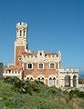
Castello Tafuri, built in 1933

View of the Castello Tafuri and the Tonnara


.JPG)
supporting documents
- ↑ Statistiche demografiche ISTAT. Monthly population statistics of the Istituto Nazionale di Statistica , as of December 31 of 2019.
Web links

Augusta | Avola | Buccheri | Buscemi | Canicattini Bagni | Carlentini | Cassaro | Ferla | Floridia | Francofonte | Lentini | Melilli | Noto | Pachino | Palazzolo Acreide | Portopalo di Capo Passero | Priolo Gargallo | Rosolini | Solarino | Sortino | Syracuse