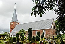
Bredebro
| Bredebro | ||||
|
||||
| Basic data | ||||
|---|---|---|---|---|
| State : |
|
|||
| Region : | Syddanmark | |||
|
Municipality (since 2007) : |
Tønder | |||
| Coordinates : | 55 ° 3 ' N , 8 ° 50' E | |||
|
Population : (2020) |
1,429 | |||
| Postal code : | 6261 | |||
 |
||||
Bredebro is a village in the former municipality of the same name in North Schleswig , the most south-western part of Denmark .
Bredebro emerged as a village on the western Ochsenweg near the church of Brede . The place, which had formed its own rural community in the Tondern district since 1871 , only gained importance with the opening of the Marschbahn in 1889, especially since two years later a branch line to Lügumkloster was built, which was later connected to Aabenraa . The union of North Schleswig with Denmark in 1920 brought the union of the rural communities around Bredebro to the parish of Brede. This united in 1970 with several neighboring communities to form the municipality of Bredebro . Since 2007 it has been part of the Tønder Municipality based in Tønder .
Individual evidence
- ↑ Statistics banks -> Befolkning og valg -> BY1: Folketal January 1st efter byområde, alder og køn (Danish)
Web links
- Website of the municipality (Danish)

