
Broad Wardtley
| Broad Wardtley | ||
 |
||
| Data | ||
| Water code | DE : 279112322 | |
| location | Wesel District , North Rhine-Westphalia , Germany | |
| River system | Rhine | |
| Drain over | Borthsche Ley → Schwarzer Graben → Xantener Altrhein → Rhine → North Sea | |
| origin |
Standing vertex area at Gindericher Straße 51 ° 38 ′ 8 ″ N , 6 ° 31 ′ 43 ″ E |
|
| muzzle | partial seepage near Elverich (former source) 51 ° 37 ′ 8 ″ N , 6 ° 34 ′ 28 ″ E , partially in the Borthsche Ley Coordinates: 51 ° 37 ′ 56 ″ N , 6 ° 31 ′ 3 ″ E 51 ° 37 ′ 56 ″ N , 6 ° 31 ′ 3 ″ E
|
|
| length | 4.3 km | |
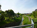
The Breiten Wardtley is a 4.28 km long river with the code number 279112322. Originally it flowed from the main Rhine dike at Elverich in a north-westerly direction; south of Büderich and Ginderich united with the Borthschen Ley . This in turn joins the Schwarzen Graben shortly afterwards and finally flows into the Old Rhine at Unterbirten in the Bislicher Insel nature reserve .
Due to subsidence , the direction of flow had partially reversed, and parts of the water had dried up. As part of a renaturation measure in 2010 and 2011, the direction of flow of the stream was finally reversed over a length of 1.4 km from Gindericher Strasse in the direction of Elverich. The previously straight course of the water was brought into a meandering shape. The brook now also diverts the rainwater from the Büderich bypass for infiltration. A pumping station on Venloer Strasse will continue to pump the water to the Rhine .
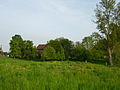
The former old river channel is dominated by the use of arable land, and in the vicinity of the water body by the use of grassland. The creek is typical landscape trees, poplar - head rows of trees lined and hedges, making it an ornithological and valuable landscape habitat is and for endangered plant and animal species of importance. Amphibians , reptiles and cave breeders should be mentioned in particular .
The width Wardtley is within the protected landscape Poll / Ginderichswardt .
gallery
- Broad Wardtley


Web links
Individual evidence
- ↑ a b District government Düsseldorf: FLOOD AREA SYSTEM XANTENER ALTRHEIN / SCHWARZER GRABEN short report ( Memento of the original from May 24th 2015 in the Internet Archive ) Info: The archive link was inserted automatically and not yet checked. Please check the original and archive link according to the instructions and then remove this notice.
- ^ Rheinische Post, Wesel edition, February 8, 2010: A stream is turned around
- ↑ New bed for old Bach NRZ from July 23, 2010
- ↑ Kreis Wesel: Landscape protection area L 7: Poll, Ginderichswardt