
Bislicher island
Coordinates: 51 ° 39 ′ 5 ″ N , 6 ° 30 ′ 27 ″ E


The Bislicher Insel lies between Ginderich and Xanten in the Wesel district and is one of the few remaining wetlands in Germany . Geographically, however, it is not an island. The total area is 12 km², of which 10.53 km² are designated as a nature reserve.
Creation of the Bislicher Island
The Bislicher Insel was created by changing the course of the Rhine . At the time of the Romans there existed next to today's Bislich an island in the Rhine, which was surrounded by a meander south and north by the Rhine itself. Later the river bed shifted further and further south and displaced the village of Birten several times until it was completely in the area of today's Xanten Old Rhine around 200 years ago.
The drawing by the Xanten cartographer Johann Bucker makes it clear that the so-called Bislicher Island - as the area looks like today - did not even exist around 1713. The Rhine flowed through what is now the Old Rhine arm . Around the place where Krabben Orth was at the time, the area of today's Bislicher Island was later created through hydraulic engineering . The old Rhine arm became a side arm.

Because of the long detour, Frederick the Great had the Rhine straightened through the Bislicher Graben in 1788, which roughly corresponds to the current course of the Rhine. As a result of this human intervention, the old main arm became a silent arm of the Rhine (at the foot of the hill in front of Birten), which today is only connected to the Rhine via the “Göt” ditch or during floods . Large parts of the water surface are also due to the gravel extraction. Structural remains (such as a large sheet pile wall) are still reminiscent of this post-war use and give the area a special charm. The Bislicher Insel is a floodplain during high water.
In 1982 the municipal association of the Ruhr area began to acquire part of the Bislicher Insel. The aim is to protect and preserve the area. In the course of this, a public recreation area was closed and new water areas were artificially created instead. The centerpiece of the nature reserve is the Xanten Old Rhine , which is over five kilometers long and has a wide range of aquatic and bank plants as well as softwood alluvial forests . Numerous bodies of water created by gravel extraction lie within the grassland area in landscapes that are regularly flooded by the Rhine. Flood turf characterizes the lower lying areas, while on the banks of the Rhine various willow , ash and elm forests contribute to the diversity of the existing habitats. The sea can stocks on Bislicher Insel are considered to be the largest in North Rhine-Westphalia.
When the Rhine floods in May 1983, the lock and dike broke on Bislicher Island.
The rock salt mining under the Bislicher Insel will cause subsidence of up to 3.5 meters on the surface between 1993 and 2025 ; these favor the rewetting of the groundwater-fed Old Rhine.
- Bislicher island

The landscape of the Bislicher Island

An old arm of the Rhine

View from the 3rd observation pulpit

Landscape view

View from the 2nd observation pulpit to the wintry Bislicher Island

Bislicher Insel: typical oxbow lake scene


Wildlife of the nature reserve
The Bislicher Island is particularly important for birds that rely on wetlands . A large number of rare butterfly and snail species can also be observed there.
Bird species
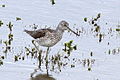
In addition to mostly 20,000 to 30,000 arctic wild geese (mostly gray , bean and white- fronted geese ), rare and endangered species overwinter and nest here. For example, the largest cormorant colony in North Rhine-Westphalia is on Bislicher Island, but Nile , Canada, and burnt and pygmy geese have also settled on Bislicher Island. In addition, storks and herons can be observed there.
Since 2000, individual storks have been sighted again and again, and three breeding aid sites have been set up. Since 2005 up to 3 pairs of storks have been breeding on the island every year, and more storks nest in the area. Sometimes up to 20 storks gather on the island's meadows before the autumn flight.
Species of common interest according to the fauna-flora-habitat and bird protection guidelines are found in the nature reserve in particular
- Combed Newts
- Bitterlings , river lampreys and wolffish
- White stork
- Tree hawks
- Black kites
- Bitterns
- Little ringed plover
- Forest , Bruch and Dark Water Strider
- Common snipe , curlew , greenshank , ruff , redshank , godwit
- Goosander , teal , teal , shoveler , whooper swan , pintail , pochard and pygmy hawk
- Lapwings
- White-fronted geese and bean geese
- Common terns and black terns
- Nightingales
- Reed Warbler
- Oriole
- Marsh harriers
- Corncracks
- Meadow pipit and
- Little Grebe .
- Some of the birds observed on Bislicher Island

Osprey

Common tern with fish prey

Great Egret
Greenshank Limikole

The rare dwarf goose overwinters on Bislicher Island

Stork "harvesting" on Bislicher Island.


Two projects aimed at conserving biodiversity deserve special mention:
- On November 12, 2004 , two beaver families with a total of twelve animals were released on Bislicher Insel in Xanten . This should create a new population on the Lower Rhine after the last beaver of the Lower Rhine was killed in Duisburg in 1877 .
- As early as 1999 , the French Christian Moullec flew in an ultralight aircraft accompanied by 30 specimens of the endangered pygmy geese from Finland to the Lower Rhine . The geese were imprinted and raised on a costumed human shortly after their birth . So they followed Christian Moullec on a route that did not hunt the geese. Although pygmy geese are under protection in Europe, their appearance is only slightly different from white-fronted geese, where hunting is permitted. In the following year it could be observed how a large part of the pygmy geese made their way to the breeding areas in Finland and back to the Lower Rhine again on the route determined by humans. In order to secure the population of the dwarf geese permanently, several hundred geese are to be stamped in this way on the new flight route in the coming years.
Driving in the nature reserve, riding and swimming is prohibited in order to protect these animals. In summer, the nature reserve also serves as pastureland .
Fish species
Due to its genesis, the waters of the Bislicher Insel have a very heterogeneous population of fish species. The actual old river channel of the Rhine has a species population typical of the Lower Rhine in almost all age groups. In a study in 1998, u. a. Carp , eel , pikeperch , pike , bream , ruff , perch , roach , more rarely also rudd , three-spined stickleback , nine-spined stickleback , loach , sunfish , crucian carp , white bream , tench have been detected.
The fish population is at risk in the summer due to its shallow depth and high nutrient content ( hypertrophy ), which creates unfavorable oxygen conditions in the water. However, regular flooding of the channel outlet ensures immigration from the Rhine.
The constellation in the former gravel pit waters is completely different. Due to the rarer flood events, the perch coenoses typical of the region can be seen here, with few adults and a high proportion of juveniles. Middle age groups are almost completely absent. This monocenosis is justified by the trough-like banks with almost no spawning and retreat opportunities for other species.

Vegetation and flora of the nature reserve
The majority of the vegetation cover is taken up by plant communities of flood plains, fringes, tall perennials and economic grassland. In addition to characteristic species such as white ostrich grass ( Agrostis stolonifera ), kinky foxtail grass ( Alopecurus geniculatus ) and platthalm rush ( Juncus compressus ), rarer species such as strawberry clover ( Trifolium fragiferum ) also grow in the floodplain . On roadsides are z. B. Common ox-tongue ( Anchusa officinalis ), rose mallow ( Malva alcea ), nodding thistle ( Carduus nutans ) and short-eared black nettle ( Ballota nigra subsp. Meridionalis ). Yellow meadow rue ( Thalictrum flavum ) and marsh ragwort ( Senecio paludosus ) grow in the nitrogen-rich, moist tall herbaceous corridors . The European nettle silk ( Cuscuta europaea ) is parasitic on the great nettle ( Urtica dioica ). Particularly noteworthy are the colorful blooming, species-rich meadows in the dry grassland with meadow sage ( Salvia pratensis ), bulbous buttercup ( Ranunculus bulbosus ), field man's litter ( Eryngium campestre ) and species that occur very rarely in the region such as rough violet ( Viola hirta ), meadows - Yellow star ( Gagea pratensis ), meadow caraway ( Carum carvi ), caraway hairline ( Peucedanum carvifolia ), medium trembling grass ( Briza media ), small meadow rue ( Thalictrum minus subsp. Minus ) and carnation summer root ( Orobanche caryophyllacea ). On the banks of the Rhine there are many neophytes such as B. Ash maple ( Acer negundo ), Mexican goose foot ( Dysphania ambrosioides ), dog's tooth ( Cynodon dactylon ) and Argentine nightshade ( Solanum physalifolium subsp. Nitidibaccatum ). The rare French sedge grows along the edge of a path and the endangered Venus woman's mirror ( Legousia speculum-veneris ) can be found at the edge of the field .
Information center "NaturForum"

In a former homestead in the middle of the island there is a visitor center, which houses the permanent exhibition "AuenGeschichten". This is operated by the regional association Ruhr Grün. The opening times of the NaturForum can be inquired about by telephone or via the Internet and guided tours of the island for groups and school classes can be arranged. The Bislicher Insel has a network of hiking trails, and many cyclists go on tours in the island area, where they can cross over to the other side of the Rhine with the passenger ferry that stops nearby during the summer.
literature
- Michaela Aufleger (Red.): Caelius and after that? History and future of the Fürstenberg and the Bislicher Insel near Xanten. Table Ronde in Xanten from 18.-19. June 2009 (= materials for the preservation of monuments in the Rhineland , vol. 23). Published by the LVR Office for Ground Monument Preservation in the Rhineland. Waldenmaier, Treis-Karden 2011. ISBN 978-3-9811909-4-6 .
- Elisabeth Schnickers, Diether Eberhardt: Birds of the Bislicher Insel (= Limnological series of publications on waters and wastewater, issue 28). Düsseldorf, August Bagel Verlag 1960.
Web links
Individual evidence
- ^ "Bislicher Insel" nature reserve in the specialist information system of the State Office for Nature, Environment and Consumer Protection in North Rhine-Westphalia , accessed on February 23, 2017.
- ↑ Julia Obladen-Kauder: Late medieval and modern images and maps of the Fürstenberg and the Bislicher Insel . In: Michaela Aufleger (Red.): Caelius and after that? History and future of the Fürstenberg and the Bislicher Insel near Xanten . Waldenmaier, Treis-Karden 2011, pp. 67–86.
- ↑ Erich Wisplinghoff : Explanations from 1984 on: Johann Bucker, map of the Rhine from Duisburg to Arnheim from 1713 . North Rhine-Westphalian State Archives, Düsseldorf 1984, pp. 5–10.
- ↑ Antje Bräuning, Jan Kirchhof: Mining under nature reserve: Deliberate increase in the water level of the Xanten Old Rhine through rock salt extraction under the Bislicher Island . In: Kali und Steinsalz , year 2009, issue 3, published by the Association of the Potash and Salt Industry e. V., Berlin
- ^ Regional Association Ruhr (ed.): Bislicher Insel. Nature and cultural landscape in the flow of time , clear text, Essen 2010.
- ↑ Excursion of the Bochum Botanical Association with a list of plants on June 12, 2010
- ↑ http://www.metropoleruhr.de/freizeit-sport/natur-erleben/bislicher-insel.html
- ↑ Information page of the NABU Wesel


Bleibach with adjoining wet meadows | Bagel forest in the Wackenbruch | Bislicher Island | Bislicher Meer and Wat Ley | Diersfordt Forest | Drevenacker dunes | Droste Woy, Rheinaue between Wesel and Bislich | Lippeaue (WES-092) | Lipperandsee | Renaturation site Büdericher Ziegelei | Rheinaue Bislich-Vahnum | Rheinaue between Büderich and Perrich | Rhine foreland east of Wallach | Weseler Aue and Leygraben near Flüren


Old Rhine, Jenneckes Gatt, Niepgraben | Bachtal am Hasenkamp | Bachtal am Wefelnberg | Brook valleys southeast of Hünxe | Bagel forest in the Wackenbruch | Inland dunes on Lichterholzweg | Bislicher Island | Bislicher Meer and Wat Ley | Blink | Quarry and floodplain forest and adjacent oak forest on the eastern edge of the Leucht | Bruckhauser Mühlenbach | Gloamwood | Diersfordt Forest | Dingdener Heide | Drevenacker dunes | Droste Woy, Rheinaue between Wesel and Bislich | Erlenbruchwald and Landwehr in the Leucht | Wetland near Menzelen-Ost | Wet meadows on the Neuenroisfeld road | Wet meadows Bucholter Bruch and north slope Testerberge | Research area in the Orsoyer Rheinbogen | Fossa Eugeniana north of the Kamperbrucher field | Fürstenberg | Gartroper Mühlenbach | Grenzdyck | Sea of Hagen / Sea of Bellinghover / Lange Renne | Hasenfeld and Rhine foreland between Eversael and Ossenberg | Hemmings Schlinke | Hohe Ley, Wesendonker ditch, Urselmanns Ley, Tacke Ley | Hünxer Bachtal | In the fort west of the Vellenfurth | In the Fens | Island in the Haferbruchsee | Isselniederung | Issumer Fleuth | Rabbit Mountains | Kirchheller Heide, Schwarzbach | Little Dingdener Heide | Krummbeck | Luminous | Lichtenhagen | Lippeaue (WES-001) | Lippeaue (WES-092) | Lipperandsee | Loosen Mountains | Momm depression | Mumbeck Bach | Nieder Heide am Egelsberg | Niederkamp and Mönchschall | Nieper Altrheinrinne near Bloemersheim | Nieper Altrheinrinne | Northern Tüschenwald | Upper Hollebach | Plankenbach | Spring brook system Siegewinkelbach | Source stream system Osterbach / Langefortsbach | Rayener Mountain | Reeser Schanz, Rheinaue between Obermörmter and Vynen, near Gut Grindt and Haus Lüttingen | Renaturation site Büdericher Ziegelei | Rheinaue Bislich-Vahnum | Rheinaue Walsum / Dinslaken | Rheinaue between Büderich and Perrich | Rhine foreland north of the Ossenberger Schleuse | Rhine foreland east of Wallach | Rhine foreland between Mehrum and Emmelsum | Rigaud's bush | Risswald | Scholtenbusch | Schwafheimer Bruch | Stapelbach | Steinbach | Stollbach | Torfvenn / Rehrbach | Üfter, Rüster and Emmelkämper Mark | Weseler Aue and Leygraben near Flüren | Winkelscher Busch