Burner green
|
Burner green
City of Lehesten
Coordinates: 50 ° 26 ′ 13 ″ N , 11 ° 28 ′ 10 ″ E
|
|
|---|---|
| Height : | 703 m above sea level NHN |
| Residents : | 150 (2012) |
| Incorporation : | January 22, 1994 |
| Postal code : | 07349 |
| Area code : | 036652 |
|
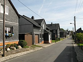
Dorfstrasse at the north-western entrance to the village
|
|
Brennersgrün is a district of the city of Lehesten in the Saalfeld-Rudolstadt district in Thuringia .
location
Brennersgrün is located in the southern tip of the Saalfeld-Rudolstadt district and partly shares a border with Bavaria . The state road 2374 connects the district with the hinterland. The district is located on a hilly plateau of the Thuringian Slate Mountains surrounded by forest . Lehesten is located to the north and can be reached via a winding and sloping route of the road. The altitude is 715 meters above sea level . The district is thus the highest village in the district.
history
The place was first mentioned in 1187. Slate mining , forestry work and limited agricultural use of the areas around the village as well as tourism (except during the GDR era) were and are the sources of income for the citizens.
On January 22, 1994 the incorporation to Lehesten took place. In 2012 150 people lived in the district.
tourism
The Rennsteig , an approx. 170 km long ridge path of the Thuringian Forest from Hörschel near Eisenach to Blankenstein, runs through the village .
Web links
Individual evidence
- ^ Wolfgang Kahl : First mention of Thuringian towns and villages. A manual. 5th, improved and considerably enlarged edition. Rockstuhl, Bad Langensalza 2010, ISBN 978-3-86777-202-0 , p. 41.
- ↑ Brennersgrün on the website of the city of Lehesten. Retrieved August 28, 2020 .
