Brodersenstrasse
| Brodersenstrasse | |
|---|---|
| Street in Munich | |
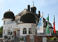
| Villa-like office building at Brodersenstrasse 36 | |
| Basic data | |
| State capital | Munich |
| Borough | Bogenhausen |
| Name received | 1930 |
| Connecting roads | Schnorr-von-Carolsfeld-Straße, Dornacher Weg |
| Cross streets | Barlowstrasse, Seidleinweg, Plankenhofstrasse, Max-Nadler-Strasse, Max-Proebstl-Strasse, Savitsstrasse, Mäleßkircherstrasse, Glücksburger Strasse, Kunihohstrasse, Küstnerstrasse |
| Places | Braklplatz (not designated) |
| Numbering system | Orientation numbering |
| Line 8 (airport line) | Englschalking S-Bahn station |
| use | |
| User groups | Pedestrian traffic , bicycle traffic , individual traffic |
| Road design | two lanes, only partially with a sidewalk |
| Technical specifications | |
| Street length | 1.4 km |
The Brodersenstraße is a city road in the 13th district (Bogenhausen) of Munich . It leads from Englschalking to the southeast in the direction of Dornach , a district of the neighboring community of Aschheim in the district of Munich . It thus leads to the only transition from the city district 13 of the state capital to the municipality of Aschheim that can be used for motor vehicles.
course
At the intersection with Barlowstrasse, the street continues the Schnorr-von-Carolsfeld-Strasse coming from the historic village center of Englschalking, continuing the house number counting at that time (starting with no.24, now broken off), and after around 100 m crosses the S-Bahn - Line S 8 to Munich Airport , on which the freight traffic of the Munich northern ring of the railway also takes place, on a level, barrier-free crossing, continues through a former brick factory, which is accessed in the north by other roads, and crosses the one in the north-south - Direction of the guided street Max-Proebstl-Straße / Max-Nadler-Straße. Here to the south is the complex of the Rudolf Steiner School and the Friedel Eder School for curative education and the cleared area of a refugee camp from the 2010s on the southwest corner. To the northeast is a small apartment building complex. At this point the Englschalking district merges into the Daglfing district . East of the confluence with Savitsstrasse (Braklplatz, not designated), Brodersenstrasse crosses the north-south axis Kunihohstrasse / Glücksburger Strasse at a garden center and turns into Dornacher Weg at Küstnerstrasse, which bypasses the Riem training track to the north. The road route continues a few meters to the east as an unsupervised dirt road to a bridge over the Hüllgraben and then ends. Brodersenstrasse is approx. 1.4 km long.
Development
To the west of the S-Bahn, the buildings from the first half of the 20th century have largely been demolished and replaced by new buildings. To the west of the S-Bahn, another listed villa-like office building (No. 36) is accessible from Brodersenstrasse, which today belongs to a building materials store. There are two older houses between the S-Bahn and Max-Proebstl-Straße. Nothing has survived from the Möhl & Schnizlein nursery of the former Munich court garden director Jakob Möhl . Also between Max-Nadler-Straße and Savitsstraße there is almost nothing left of the older development as a result of new buildings since the 1980s. East of Glücksburger Strasse, Brodersenstrasse leads across open fields.
At the western beginning of the street, at the intersection with Barlowstrasse and Schnorr-von-Carolsfeldstrasse, there is a natural stone pillar with a small metal cross on a small traffic island. At the corner of Kunihohstraße there is a wayside cross, the Daglfinger Wegkreuz , which was renovated in 2010 .
Planned expansion
According to the winning design by Rheinflügel Severin, Düsseldorf, presented on January 27, 2020 in the Süddeutsche Zeitung (regional section, page R1) in the controversial urban development and landscape planning ideas competition for Munich's north-east ( north-east concept) , the approximately 350 hectare, so far mainly agricultural area Areas in addition to a massive expansion of the Brodersenstraße with a guided tour of the subway in the direction of Riem via the Englschalking stations and north of Daglfing, in particular a massive development south of the street between the S-Bahn route and the Max-Proebstl-Straße up to the extended Memeler Road provided.
Origin of name
The street is named after the opera singer Friedrich Brodersen (1873–1926). The name was given after the incorporation of the “inorganic” community Daglfing.
Web links
Coordinates: 48 ° 9 ′ 16 ″ N , 11 ° 39 ′ 19 ″ E
Individual evidence
- ^ Hans Dollinger: Die Münchner Strasseennamen, 6th edition 2007, Südwest Verlag, Munich, ISBN 978-3-517-08370-4 , p. 49
- ↑ Münchner Stadtadreßbuch 1969, 114th edition, Part IV, page 124
- ↑ Wolfgang Görl: The best ideas for Munich's northeast, Süddeutsche Zeitung of January 27, 2020, page R1, with visualization


