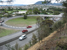
Brooker Highway
| Brooker Highway | |||||||||||||||||||||||||||||||||||||
|---|---|---|---|---|---|---|---|---|---|---|---|---|---|---|---|---|---|---|---|---|---|---|---|---|---|---|---|---|---|---|---|---|---|---|---|---|---|

|
|||||||||||||||||||||||||||||||||||||
| Basic data | |||||||||||||||||||||||||||||||||||||
| Operator: | THIS | ||||||||||||||||||||||||||||||||||||
| Start of the street: |
Hobart ( 42 ° 53 ′ S , 147 ° 20 ′ E ) |
||||||||||||||||||||||||||||||||||||
| End of street: |
|
||||||||||||||||||||||||||||||||||||
| Overall length: | 17 km | ||||||||||||||||||||||||||||||||||||
|
States : |
|||||||||||||||||||||||||||||||||||||
| Brooker Highway at Claremont | |||||||||||||||||||||||||||||||||||||
|
Course of the road
|
|||||||||||||||||||||||||||||||||||||
The Brooker Highway is an urban highway in the south of the Australian state of Tasmania . It is also known as the Northern Outlet and is the main artery through the northern suburbs of Hobart and connecting the capital with the cities in northern Tasmania. It is one of the busiest roads in Tasmania.
course
The Brooker Highway runs from Hobart city center approximately 17 km north through the northern suburbs and the town of Glenorchy . It connects several industrial and commercial areas along the old main road. The Brooker Highway is a motorway-like road and, with the exception of the connection to the Domain Highway (B36), only the northern sections of the route have elevation-free entrances and exits. The most important level connections are designed as traffic lights and roundabouts .
history
Old Brooker Avenue was built in 1961 as a two lane road from the end of Liverpool Street to Elwick Road . In 1965, the Hobart Area Transportation Study came out, which contained an extensive development plan for the Brooker Highway. By 1968 Brooker Avenue had been doubled and road works had already reached Berriedale . In 1977 the highway turned north and joined the Claremont Link Road . In 1983 the Brooker Highway reached its present length and forms the connection to Granton and the bridge at Bridgewater . The Brooker Highway replaced the old Midland Highway between the city center of Hobart and Granton, which ran along Elizabeth Street , New Town Road and Main Road through the densely populated areas of New Town, Moonah, Glenorchy, Rosetta, Montrose, Claremont and Berriedale . This was the first major highway construction in the Hobart area and was named after Tasmania's Minister of Transport at the time, Edward Brooker .
course
The highway begins in Hobart city center at the junction with Eastern Outlet (A3), Davey Street (A6), and Macquarie Street (A6). The Eastern Outlet (on the Tasman Highway) heads east over the Tasman Bridge , past the airport and on to the east coast of the island. Davey Street and Macquarie Street lead to the Southern Outlet , which in turn directs traffic to Kingston and Huonville .
In addition to the connection to Davey Street and Macquarie Street, the main connection in the city center is the three-lane roundabout at the northeast end of Liverpool Street . Because this roundabout was built in the immediate vicinity of what was then the main train station, it is still called the '' Railway Roundabout '' today. The sunken, planted center of the roundabout serves as a pedestrian crossing and is connected by tunnels to both sides of Liverpool Street, the location of the old train station to the northeast, and Domain and the suburb of The Globe to the northwest. There used to be an intersection with no traffic lights instead of the roundabout, but the gradual increase in traffic, especially from the east bank of the Derwent River , soon began to create rush hour traffic jams. Traffic lights were set up, which initially eased the situation, and later added direct connections from Tasman Bridge to Davey Street and Macquarie Street to further improve the flow of traffic. Other streets in the city center are also connected to the Brooker Highway, but most of them are restricted for their entire length to the edge of the city center on Risdon Road .
On the section through Glenorchy, the Brooker Highway has long, multi-lane routes, e.g. B. Risdon Road , Elwick Road and Derwent Park Road . The highway is in acceptable condition for its age, with traffic jams only a few hours a day.
Trees limit the median for several kilometers and fences at the edges of the road ensure that pedestrians have no access. The highway passes Domain , Cornelian Bay Hockey Grounds , Rugby Park , Royal Hobart Showgrounds , Tattersall Park, and Derwent Entertainment Center .
At its northern end in Granton, the Brooker Highway is connected to the Midland Highway (N1) - towards Launceston and the Lyell Highway (A10) - towards the west coast.
Recent history
In April 2007, the Department of Infrastructure, Energy and Resources wanted to replace the old, rusty street lights between Risdon Road and Cleary's Gates Road. They are over 40 years old and were the first street lights on the highway. This led to a dispute with the Hobart City Council, who argued that the street lights were still in good condition and a familiar detail on the Hobart entrance. Eventually the city council agreed to the exchange, but asked Minister Jim Cox to keep the ornate lantern arms and have them put on new masts.
The Department of Infrastructure, Energy and Resources would also like to re-route the exits on Elwick Road and Goodwood Road so that traffic lights can be saved and the routing becomes clearer. The Goodwood roundabout is to be replaced by traffic lights. The Tasmanian state government also announced that it intends to revise the connection to the Domain Highway in order to improve traffic flows. As part of this, the Brooker Highway between Domain Highway and Risdon Road is to be expanded to six lanes.
Recently, the government also faced calls from the city for improvements to the highway pedestrian bridges in Goodwood. In particular, stairs that represent obstacles for the elderly and the disabled should disappear.
Emergency landing on Highway 2010
On April 4, 2010, the 18-year-old pilot Patrick Humpries made global headlines when he used the usually busy highway as an emergency landing strip due to problems with his aircraft. Humpries was uninjured and there were no accidents with cars.
Entrances and exits
|
Brooker Highway |
|||
| Entrances and exits to the south | Distance to Tasman Highway (km) |
Distance to Lyell Highway (km) |
Entrances and exits to the north |
|
End of Brooker Highway to Davey Street to Hobart |
0 | 18.5 |
Start of Brooker Highway from Macquarie Street |
| Bellerive, Sorell Tasman Highway |
Bellerive, Sorell Tasman Highway |
||
| No entry | 0.2-0.3 | 18.3-18.2 |
Hobart Collins Street, Sackville Street |
|
Hobart Liverpool Street (West) (exit only) |
0.4 | 18.1 |
Hobart Liverpool Street (West) (exit only) |
| Bellerive Liverpool Street (East) |
Hobart Bathurst Street (entrance only) |
||
|
Hobart Bathurst Street (entrance only) |
Bellerive Liverpool Street (East) |
||
| Same Edward Street |
0.6 | 17.9 | No entry |
|
Hobart Brisbane Street (exit only) |
0.7 | 17.8 |
Hobart Brisbane Street |
| Glebe Scott Street, Lillie Street, Davenport Street |
0.8-1.0 | 17.7-17.5 | No entry |
| North Hobart Warwick Street |
1.1 | 17.4 | North Hobart Warwick Street |
| Glebe Shoobridge Street |
1.3 | 17.2 | North Hobart Burnett Street |
| North Hobart Burnett Street |
|||
| No entry | 1.7 | 16.8 | North Hobart Federal Street |
| Queens Domain Clearys Gates Road |
2.4 | 16.1 | No entry |
| New Town Park Street (exit only) |
2.6 | 15.9 | New Town Park Street |
| Bellerive, Hobart Domain Highway |
3.2 | 15.3 | Bellerive, Hobart Domain Highway |
| New Town Risdon Road |
4.1 | 14.4 | New Town Risdon Road |
| Moonah Bowen Road |
4.9 | 13.6 | Moonah Bowen Road |
| Lutana Ashbolt Crescent |
Lutana Ashbolt Crescent |
||
| Lutana Bowen Road |
5 | 13.5 | No entry |
| Derwent Park (Lutana) Derwent Park Road |
5.6 | 12.9 | Derwent Park (Lutana) Derwent Park Road |
| Goodwood Lampton Avenue (East) |
6.3 | 12.2 | Derwent Park Lampton Avenue (West) |
| Derwent Park Lampton Avenue (West) |
|||
| Derwent Park Howard Road |
7.1 | 11.4 | Derwent Park Howard Road |
| Goodwood Renfrew Court |
Goodwood Renfrew Court |
||
| Dowsing Point, Bowen Bridge Goodwood Road |
7.5 | 11 | Dowsing Point, Bowen Bridge Goodwood Road |
|
Glenorchy Elwick Road |
7.6 | 10.9 |
Glenorchy Elwick Road |
| Derwent Entertainment Center Loyd Road |
8th | 10.5 | Derwent Entertainment Center Loyd Road |
| Montrose Duncan Street |
9.1 | 9.4 | Montrose Duncan Street |
|
Foreshore Road ( Dead End Street ) |
Foreshore Road ( Dead End Street ) |
||
|
Dodson Street ( Dead End Street ) |
9.6 | 8.9 |
Dodson Street ( Dead End Street ) |
| Berriedale, Rosetta Main Road |
10 | 8.5 | Berriedale, Rosetta Main Road |
| Berriedale, Collinsvale Berriedale Road |
10.6 | 7.9 | Berriedale, Collinsvale Berriedale Road |
| Chigwell, Claremont Claremont Link Road |
12.4 | 6.1 | Chigwell, Claremont Claremont Link Road |
| Claremont Abbotsfield Road |
13.7 | 4.8 | Claremont Abbotsfield Road |
| Claremont Hilton Road |
15th | 3.5 | Claremont Upper Hilton Road |
| Start of a motorway-like road | 17.2 | 1.3 | End of a motorway-like road |
| Granton Black Snake Road (entrance only) |
17.9 | 0.6 | Granton Black Snake Road |
| Granton Main Road (exit only) |
18.3 | 0.2 | no entrance |
|
New Norfolk , Queenstown Lyell Highway |
18.5 | 0 |
New Norfolk , Queenstown Lyell Highway |
|
Start Brooker Highway from the Midland Highway |
End of Brooker Highway to Midland Highway to Bridgewater , Launceston |
||
Web links
Individual evidence
- ↑ a b Tasmanian Expressways . ozroads.com.au. 2003. Retrieved April 30, 2007.
- ↑ Between Davey Street and Cleary's Gates on the crest of the ridge, the highway is also called Brooker Avenue .
- ↑ Davey Street and Macquarie Street are one-way streets; Davey Street runs to the southwest and Macquarie Street to the northeast through the city center.
- ^ A b Council poles apart on Brooker lights switch , The Mercury. Retrieved April 11, 2007.
- ↑ Infrastructure Australia Priorities Welcomed , Tasmanian Government. December 19, 2008. Retrieved December 24, 2008.
- ↑ Stephen White: Teenage Pilot Escapes Unhurt After Crash Landing on Motorway . The Mirror. Hobart (April 5, 2010)
- ↑ Plane crashes on city highway . In: The Sydney Morning Herald , April 4, 2010.


