Brookside, Alabama
| Brookside | |
|---|---|
 The St. Nicholas Church at Brookside |
|
| Location in County and Alabama | |
| Basic data | |
| Foundation : | 1886 |
| State : | United States |
| State : | Alabama |
| County : | Jefferson County |
| Coordinates : | 33 ° 38 ′ N , 86 ° 55 ′ W |
| Time zone : | Central ( UTC − 6 / −5 ) |
| Residents : | 1,363 (as of 2010) |
| Population density : | 87.9 inhabitants per km 2 |
| Area : | 15.5 km 2 (approx. 6 mi 2 ) of which 15.5 km 2 (approx. 6 mi 2 ) is land |
| Height : | 110 m |
| Postal code : | 35036 |
| Area code : | +1 205 |
| FIPS : | 01-09736 |
| GNIS ID : | 0114968 |
| Website : | www.brooksidealabama.com |
| Mayor : | Roger McCondiche |
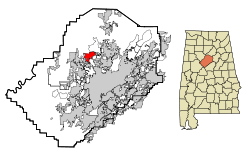
Brookside is a former mining town that was first settled by immigrants from Eastern Europe. The city is located in western Jefferson County in the US state of Alabama . In 2010 Brookside had 1,363 residents. The place has a total area of 15.5 km².
geography
Brookside is located in central Alabama in the southern United States.
Nearby places include Graysville (immediately adjacent to the west), Mount Olive (immediately adjacent to the northeast), Adamsville (immediately adjacent to the south), Birmingham (1 km south) and Fultondale (3 km southeast).
history
The first settlers arrived in the area in 1838. The Brookside mine was opened in 1886 by the Coalburg Coal and Coke Company . A year later the mine was bought by the Sloss Iron and Steel Company , who mined fuel for their blast furnaces there. The first school was founded in 1900 and a post office was opened in 1971.
Heavy rains in 2003 caused Five Mile Creek to overflow its banks and flooded large parts of the historic city center.
The town's name may derive from a small stream nearby.
traffic
One kilometer west of the city is Interstate 22 , four kilometers east of Interstate 65 and six kilometers east of US Highway 31 . A few kilometers south there is also a connection to Interstate 20 and Interstate 59 .
Birmingham-Shuttlesworth International Airport is 13 kilometers to the southeast .
Demographics
According to the 2000 census , Brookside had 1,393 residents, distributed among 546 households and 393 families. The population density was 89.9 inhabitants / km². 90.52% of the population were white, 8.69% were African American. The median income was $ 29,792 per household, with 18.2% of the population living below the poverty line .
By the 2010 census , the population had dropped to 1,363.
Web links
- Official website (English).
- Statistical data Brookside (Engl.)
- Brookside in the Encyclopedia of Alabama (Engl.)
Individual evidence
- ↑ a b Website of the US Census Bureau (English)
- ↑ Place Names in Alabama , University of Alabama Press, Tuscaloosa 1989, p. 24 ( on Google Books )
