Brule River (Lake Superior)
| Brule River | ||
|
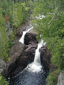
Devil's Kettle in Judge CR Magney State Park |
||
| Data | ||
| Water code | US : 655530 | |
| location | Cook County in Minnesota (USA) | |
| River system | Saint Lawrence River | |
| Drain over | Saint Marys River → St. Clair River → Detroit River → Niagara River → Saint Lawrence River → Atlantic Ocean | |
| source |
Vista Lake 47 ° 59 ′ 57 ″ N , 90 ° 29 ′ 1 ″ W. |
|
| Source height | 566 m | |
| muzzle | 25 km northeast of Grand Marais in the Upper Sea Coordinates: 47 ° 49 ′ 0 ″ N , 90 ° 3 ′ 0 ″ W 47 ° 49 ′ 0 ″ N , 90 ° 3 ′ 0 ″ W |
|
| Mouth height | 188 m | |
| Height difference | 378 m | |
| Bottom slope | 5.8 ‰ | |
| length | 65 km | |
| Catchment area | 686 km² | |
| Flowing lakes | Horseshoe Lake , Northern Light Lake | |
The Brule River is a river in Cook County in northeast Minnesota (USA).
The Brule River has its origin in Vista Lake in the Boundary Waters Canoe Area Wilderness not far from the Canadian border. The river flows through the adjacent Horseshoe Lake to the north and leaves it in an easterly direction. He later turns south. It flows through Northern Light Lake and maintains its direction of flow to the south.
In Judge CR Magney State Park , the Brule River overcomes Devil's Kettle , an unusual waterfall that divides the Brule River and part of it disappears into the ground. The flow path of this water is not known.
Finally, the Brule River flows into Lake Superior 25 km northeast of Grand Marais . The Brule River has a length of 65 km.
Web links
Individual evidence
- ↑ Vista Lake in the United States Geological Survey's Geographic Names Information System
- ↑ Brule River in the United States Geological Survey's Geographic Names Information System
- ↑ www.lakesuperiorstreams.org
- ↑ Marissa Fessenden: The Mystery of Minnesota's Disappearing River. Smithsonian Magazine online July 30, 2015. Retrieved November 24, 2015.
