Brunner (New Zealand)
| Brunner | ||
| Geographical location | ||
|
|
||
| Coordinates | 42 ° 26 ′ S , 171 ° 19 ′ E | |
| Region ISO | NZ-WTC | |
| Country |
|
|
| region | West coast | |
| District | Gray District | |
| Ward | Eastern Ward | |
| Residents | 66 (2013) | |
| height | 20 m | |
| Post Code | 7805 | |
| Telephone code | +64 (0) 3 | |
| Photography of the place | ||
 Brunner mine |
||
Brunner was a former mining settlement in the Gray District of the West Coast regionon the South Island of New Zealand .
geography
Brunner was at the northern end of today's small town of Taylorville on the Gray River , about nine kilometers east of Greymouth .
history
Brunner was founded in the 19th century as a mining settlement of Brunnerton after Thomas Brunner found a coal seam on January 26, 1848 on the north bank of the Gray River . The same seam was discovered a second time in 1857 by John Peter Oakes . However, the actual coal mining did not begin until the 1860s when around 40 tons of coal were shipped to Nelson .
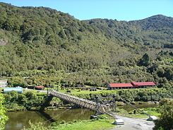
The coal mined was first on the Gray River in the direction of Greymouth , until 1876 the western section of the Midland Line reached to Brunner . Brunner was given its own breakpoint on the other side of the Gray River . The coal was brought to the loading station on wagons over the Brunner Bridge , a steel suspension bridge built in 1876 . At the beginning of the bridge there was a turntable to save space for a track curve.
Finally, in 1887, Brunner was granted borough status .
Brunner became internationally known through the great accident of 1896, when 65 miners were killed in a firedamp explosion in the Brunner mine .
population
In the years after 1945 Brunner always had a little over 1000 inhabitants. At some point the settlement was assigned to the place Taylorville . In 2013, around 66 people lived in the part of the village that used to be the miners' settlement.
economy
Brunner was monostructural oriented towards the hard coal mining and only existed because of the Brunner mine . The mine was closed in 1906 and coal was mined in other mines in the area until 1968.
literature
- AW Reed : The Reed Dictionary of New Zealand Place Names . Reed Books , Auckland 2002, ISBN 0-7900-0761-4 (English).
- Brian Newton Davis : Brunner . In: Alexander Hare McLintock (Ed.): An Encyclopaedia of New Zealand . Wellington 1966 ( online [accessed May 24, 2017]).
Web links
- Brunner coal mining township : [approx. 1900]. In: Christchurch City Libraries Heritage Photograph Collection . Christchurch City Libraries,accessed June 22, 2015.
- Brunner . In: Te Ara Encyclopedia of New Zealand . Ministry for Culture & Heritage,accessed June 22, 2015.
Individual evidence
- ↑ a b 2013 Census QuickStats about a place: Dobson . Statistics New Zealand , accessed on May 24, 2017 (English, StatsMap: Meshblock analysis from the interactive map).
- ↑ Topo250 maps - West Coast - Gray Mouth . Land Information New Zealand , accessed May 17, 2017 .
- ^ Brunner mine explosion . Christchurch City Libraries , accessed June 23, 2015 .
- ↑ a b Brunner . In: New Zealand history online . Ministry for Culture & Heritage , accessed June 22, 2015 .
- ^ Davis : Brunner . In: An Encyclopaedia of New Zealand . 1966.

