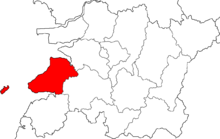
Buan
| Buan-gun | |||
|---|---|---|---|
| Korean alphabet : | 부안군 | ||
| Chinese characters : | 扶 安郡 | ||
| Revised Romanization : | Buan-gun | ||
| McCune-Reischauer : | Puan-gun | ||
| Basic data | |||
| Province : | Jeollabuk-do | ||
| Coordinates : | 35 ° 44 ' N , 126 ° 44' E | ||
| Surface: | 493.64 km² | ||
| Residents: | 66,992 (as of 2007) | ||
| Population density : | 136 inhabitants per km² | ||
| Structure: | 1 eup, 12 myeon | ||
| map | |||
|
|||
Buan County ( kor. 부안군 , Buan-gun ) is located in Jeollabuk-do Province and borders the Yellow Sea .
In 1988 the Byeonsan National Park was established. The Naesosa Temple, built in 633, is located in the district .
Administrative structure
- Buan-eup (부안읍)
- Jusan-myeon (주산면)
- Dongjin-myeon (동진면)
- Haeng-an-myeon (행안면)
- Gyehwa-myeon (계화면)
- Boan-myeong (보안면)
- Byeonsan-myeon (변산면)
- Jinseo-myeon (진서면)
- Baeksan-myeon (백산면)
- Sangseo-myeon (상서면)
- Haseo-myeon (하서면)
- Jupo-myeon (줄포면)
- Wido-myeon (위도면)
Web links
- Website of the district Buan (English)

