Buhlert (Eifel)
| Buhlert
(The Buhlert)
|
|
|---|---|
| Highest peak | nameless (near L 246) ( 508.2 m above sea level ) |
| location | City region Aachen and Düren district ; North Rhine-Westphalia ( Germany ) |
| part of | Eifel |
| Coordinates | 50 ° 39 ′ N , 6 ° 22 ′ E |
The Buhlert , also called the Buhlert , is up to 508.2 m above sea level. NHN high, wooded ridge in the Eifel . It is located in the Aachen city region and in the Düren district in North Rhine-Westphalia ( Germany ).
Geographical location
The Buhlert lies between Strauch , Schmidt and Simonskall . The national road 246 leads across , via which you can reach the hikers' parking lot west of the Gerstenhof . To the south to east the ridge falls to the Rurtalsperre (Rursee) and to the west to the north to the Kall valley with Simonskall. To the southwest, in the direction of the bush , the rising landscape leads over to the Monschau Heckenland .
history


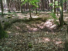
During the Second World War , the Buhlert was part of the hard-fought northern Eifel , for example during the battle in the Hürtgenwald , the scene of the defense of the Wehrmacht against the attacking US Army . Even today, trenches , bomb craters , bunkers and excavations are evidence of the heavy fighting.
The Siegfried Line with its bunkers also extended over the Buhlert, some of which are still well preserved and safely accessible today. The bunkers still preserved are the group shelters 131 and 132, the double group stand 139/140, the MG bunker 135 and a bunker for the water supply, which were built as part of the Limes program . The latter is still in operation today and is used during exercises by the volunteer fire brigade . Directly at the parking lot on the L 246 there is also a small water reservoir for the nearby Reich Labor Service Camp.
During the construction work to build the bunkers, a "bunker road" was built to supply the construction sites with the necessary material. The road is still preserved today as a paved forest path. The Reich Labor Service was responsible for the work, whose camp 7/315 was on the site of today's hikers' parking lot on the L 246. No remains of it are recognizable today.
nature
With a few exceptions, such as smaller clearings, the Buhlert is continuously and densely forested. The largest part of the forest consists of spruce stands in monoculture. As a result, there is not much biodiversity among the trees, but there are numerous plant species on the forest floor. However, there are also smaller sections with mixed or deciduous forest. The latter are monocultures of beech or birch.
The forest is used for forestry, due to the heavy fighting in World War II, there are still bullets and shrapnel in many trees, which often make the trees unusable for further processing.
See also
literature
- Adolf Hohenstein, Wolfgang Trees : Hell in the Hürtgenwald . 1st edition. Triangel-Verlag, Aachen 1981, ISBN 3-922974-01-5 .
Web links
- At the Buhlert , information on the traces of the Westwall on the Buhlert with photos, on faehreensucher.net
- Der Buhlert , information about the Buhlert with photos, on derbuhlert.com (English)
Individual evidence
- ↑ a b Topographical Information Management, Cologne District Government, Department GEObasis NRW ( Notes )
- ↑ Anneke Wardenbach: Shrapnel endanger woodcutters. Late effects of the war: damaged saws, discolored wood. In: WDR television . January 13, 2008, archived from the original on January 13, 2008 ; accessed on March 15, 2014 .