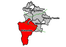
Bukombe (District)
Bukombe district
|
|||
|---|---|---|---|
| Basic data | |||
| Country | Tanzania | ||
| region | Geita | ||
| surface | 8056 km² | ||
| Residents | 224,542 (2012) | ||
| density | 28 inhabitants per km² | ||
| ISO 3166-2 | TZ-27 | ||
Coordinates: 3 ° 47 ′ S , 31 ° 6 ′ E
Bukombe is one of the five districts of the Geita region in Tanzania with the administrative center in the city of Ushirombo . The district borders in the northwest on the Kagera region , in the north on the Chato district , in the northeast on the Mbogwe district , in the southeast on the Shinyanga and Tabora regions and in the west on the Kigoma region .
geography
The district is 8,056 square kilometers and has around 225,000 inhabitants (as of 2012). It is located on the East African plateau at an altitude of 1100 to 1300 meters. More than three quarters of the area are game reserves and forest areas. The annual rainfall is between 700 and 1000 millimeters.
history
The name comes from the Sumbwa word "Bukombe", which means a ceremony at the bride price negotiation. The district was founded in 1995 by separating the Kahama district. In 2013 the Mbogwe district was split off and Bukombe has had its current form ever since.
Administrative division
The district is subdivided into the three divisions Siloka, Bukombe and Ushirombo as well as 17 communities (wards) (as of 2016):
| No. | Ward | Residents |
|---|---|---|
| 1 | Bugelenga | 8,463 |
| 2 | Bukombe | 11,706 |
| 3 | Busonzo | 10,296 |
| 4th | Butinzya | 9,877 |
| 5 | Bulega | 13,520 |
| 6th | Igulwa | 16,528 |
| 7th | Iyogelo | 7.910 |
| 8th | Lyambamgongo | 6.314 |
| 9 | Namonge | 30,654 |
| 10 | Ng'anzo | 8,922 |
| 11 | Runzewe Magh | 11,990 |
| 12 | Runzewe Mash | 16,095 |
| 13 | Ushirombo | 6,040 |
| 14th | Uyovu | 29,909 |
| 15th | Catome | 8,230 |
| 16 | Katente | 19,982 |
| 17th | Bulangwa | 8.106 |
populationThe population is growing only weakly, increasing from 214,321 to 224,542 inhabitants between 2002 and 2012. This corresponds to an annual growth of 0.7 percent, while the growth rate in the region was 2.5 percent. In 2012, half of those over five could read and write Swahili, and an additional six percent could read and write English and Swahili. 43 percent were illiterate. Facilities and services |
 |
- Education: There were 78 primary schools and 18 secondary schools in Bukombe, 16 of which were public and 2 private (as of 2019).
- Health: In 2019, one hospital, three health centers and fifteen pharmacies were available to provide medical care for the population. Of the health centers, one was private, one was owned by a religious organization, and three were state-run.
- Water: Around eighty percent of the population got their water from traditional wells or natural springs in 2019. This water is neither safe nor clean.
Economy and Infrastructure
|
Agriculture is the most important economic activity, around ninety percent of the population are dependent on it. Other activities include mining, odd jobs, trading, beekeeping, and charcoal production.
|
 |
- Roads: The T3 national road runs through the northern part of the district and connects Dodoma with Rwanda via Singida .
politics
There are several political parties in Bukombe:
| Political party | Surname |
|---|---|
| CCM | Revolutionary party |
| CUF | Civil united front |
| NFS | Reform party |
| CHADEMA | Party for Democracy and Development |
| TLP | Tanzanian Labor Party |
Nature reserves, sights
- Kigosi Game Reserve: This 7,000 square kilometer game reserve covers more than half of the district. It was established in 1983 and offers hunting and wildlife viewing.
- Moyowosi Game Reserve: In the southwest, Bukombe is part of the 6000 square kilometer Moyowosi Game Reserve, which has existed since 1981. It allows you to hunt buffalo, lions, giraffes, zebras and various antelopes.
Web links
Individual evidence
- ^ A b Tanzania Regional Profiles, 25 Geita Regional Profiles. (pdf) The United Republic of Tanzania, March 2016, p. 15 , accessed on December 14, 2019 .
- ↑ Geita Region Investment Guide 2019. (PDF) pp. 13–15 , accessed on January 28, 2020 .
- ↑ a b c d e f g h i j Bukombe District Profile. Retrieved January 28, 2020 .
- ↑ historia ya bukombe | BUKOMBE DISTRICT COUNCIL. Retrieved January 28, 2020 .
- ↑ Tanzania Regional Profiles, 25 Geita Regional Profiles. (pdf) The United Republic of Tanzania, March 2016, p. 70 , accessed on December 14, 2019 .
- ↑ Statistics | BUKOMBE DISTRICT COUNCIL. Retrieved January 28, 2020 .
- ↑ Idara ya Afya | BUKOMBE DISTRICT COUNCIL. Retrieved January 28, 2020 (Swahili).
- ↑ Tanzania Regional Profiles, 25 Geita Regional Profiles. (pdf) The United Republic of Tanzania, March 2016, pp. 169–171 , accessed on December 14, 2019 .
- ^ Tanzania Trunk Road Network. Retrieved January 28, 2020 .
- ↑ Kigosi Game Reserve. In: Tanzania Zalendo. Retrieved January 28, 2020 (American English).
- ↑ Moyowosi Game Reserve. In: Tanzania Zalendo. Retrieved January 28, 2020 (American English).

