
Bulanık (Ardanuç)
| Bulanık | ||||
|
||||
| Basic data | ||||
|---|---|---|---|---|
| Province (il) : | Artvin | |||
| District ( ilçe ) : | Ardanuç | |||
| Coordinates : | 41 ° 4 ' N , 42 ° 11' E | |||
| Height : | 1340 m | |||
| Residents : | 393 (2010) | |||
| Telephone code : | (+90) 466 | |||
| Postal code : | 08300 | |||
| License plate : | 08 | |||
| Structure and administration (as of 2012) | ||||
| Muhtar : | Özkan Kaya | |||


Bulanık is a village (in Turkish Köy ) in the Ardanuç district in the Artvin Province in northeastern Turkey . The statistics office registered 393 inhabitants for 2010. The agricultural settlement on a mountain slope is characterized by a relatively large number of haystacks and cattle stalls in massive log construction . The village was named Bulanık in the 20th century. The former place name was transcribed as Lengethev (i) or Longuthev, the linguist Sevan Nişanyan assuming a Georgian origin of the name.
location
Bulanık is located about 55 kilometers by road south-east of the provincial capital Artvin and 15 kilometers in the same direction from the small town of Ardanuç on the eastern slope of the Ardanuç River ( Ardanuç Çay , also Bulanık ), which rises on the northern slope of the Yalnızçam mountain range, which is up to 2,840 meters high Berta Suyu flows. At the confluence, a side road branches off from expressway 10 and runs in the Ardanuç valley, which in places narrows to a gorge with steep rocky slopes. Behind the town of Ardanuç, the valley widens slightly. From the road, an unpaved road winds a kilometer through meadows up to Bulanık. Three kilometers after the village in a north-westerly direction, this path reaches the church ruins Yeni Rabat , which probably belonged to the former Georgian monastery Schatberdi. Pine and oak forests alternate between pastureland.
Townscape
The picturesque village extends for almost a kilometer on a medium slope. There is a cattle trough at the entrance to the village and a drinking fountain at the upper end of the village. While the cattle shelters and feed stores are solidly made as log houses from round timber, the residential buildings consist of light modern hollow bricks or simple board walls. The houses are less stable than the granaries and stables with their traditional construction. Agriculture is mainly based on cattle breeding. Potatoes and vegetables are grown for self-sufficiency. There is no grocery store.
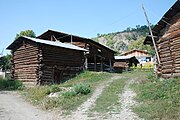
Cattle stalls, winter feed is stored on the upper floor. In the background a house
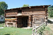
Haystacks and firewood storage


Individual evidence
- ^ Population of city, towns and villages - 2010. ( Memento of April 25, 2012 in the Internet Archive ) Turkish Statistical Institute
- ↑ Sevan Nişanyan: Adini unutan Ülke. Türkiye'de Adı Değiştirilen Yerler Sözlüğü. Istanbul 2010, p. 42