
Hausstein Castle
| Hausstein Castle | |
|---|---|
 Georg Matthäus Vischer : The vortex in the Danube (1674). |
|
| Alternative name (s): | House stone |
| Castle type : | Inselburg |
| Conservation status: | not received |
| Standing position : | Armchair |
| Place: | Neustadtl on the Danube |
| Geographical location | 48 ° 13 '47.2 " N , 14 ° 54' 6.2" E |
The castle stone house (also Haustein ) was a plant on the rocky peaks - later island - close to the so-called vortex in the Danube in the district Nabegg the municipality of Neustadtl an der Donau in the district of Amstetten in Lower Austria . The rocky island with the remains of the system was demolished in 1854 in the course of the Danube regulation by blasting, as its spur-like position in the middle of the river caused the Danube vortex.
history
Documented sources are sparse; the complex, which was part of a toll and security system consisting of several castles, was probably only occupied by burgraves or administrators. In 1314 Duke Friedrich I. pledged Hausstein, together with Werfenstein and Pain (both Upper Austria ), to Albero von Volkersdorf . The plant appears in 1351 as "Houstain nyderthalb Werbenstain" (Haustein below Werfenstein). Later, apparently in connection with the re-establishment of Greinburg in 1510 and the associated relocation of the Danube toll to Grein , the facility was abandoned and fell into disrepair.
location
The narrow arm of the Danube that separated the rocky island of Hausstein from the southern bank of the Danube was called the Lueg , also known as Lueg-Gang , Lueg-Kanal or Loch . Similar to the way up the Danube the Hößgang was used by the boatmen to bypass the vortex, the Lueggang was used by the boatmen to bypass the vortex, but even at high tide it was only navigable for ships with shallow drafts and was dry at low tide. Joseph Walcher wrote in 1781 that the Hausstein “in the oldest times” was completely connected to the right (= Lower Austrian) bank. Since then, a formal 63 fathom long shipping canal has been blasted through the rocks , which is often quite dry today, but becomes navigable as the Danube grows, and the Hausstein, like the Hößgang the Wörth, is made an island . The news from Joseph August Schultes in 1827 that the Lueg was recently created is misleading. In the same book it says a few pages further: This canal was deepened a little *) and also widened in 1774 ... along its entire 63 fathom length. *) Because it was sometimes quite dry by the little water.
The rock island with the ruins of the castle complex appears on topographical maps of the Danube spiral and the Danube vortex and on images.

Map section from 1721 with the house stone (not marked on the map) between the Lueg Gang and the Wirbl
Old colored copper engraving from 1781 with the house stone from the west

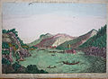
Danube vortex with the Hausstein from the south according to Joseph Walcher (1781)

Floor plan by Joseph Walcher (1791)

Danube vortex with the Hausstein from the west to Rudolf von Alt (1854)

Monument on the north bank of the Danube in St. Nikola an der Donau to commemorate the demolition of the Hausstein rock island


literature
- Norbert Grabherr : Castles and palaces in Upper Austria. A guide for castle hikers and friends of home. 3rd edition . Oberösterreichischer Landesverlag, Linz 1976, ISBN 3-85214-157-5 .
- Oskar Hille: Castles and palaces in Upper Austria then and now . Verlag Ferdinand Berger & Sons, Horn 1975, ISBN 3-85028-023-3 .
- Christian K. Steingruber : A critical consideration of the historical-topographical manual of the fortifications and mansions of Upper Austria . Upper Austrian Provincial Archives , Linz 2013.
Web links
- Hausstein auf NÖ-Burgen online , Institute for Reality Studies of the Middle Ages and Early Modern Times, University of Salzburg
Individual evidence
- ^ Josef Baumgartner: Regulations for the shipping of the vortex and eddy of the Danube. In: Allgemeine Bauzeitung. Year 25, Vienna 1860, pp. 18–24, illustration p. 21 ( online ).
- ↑ Josef Baumgartner: The nature of the vortex and eddy of the Danube and the regulatory works carried out on them. In: Allgemeine Bauzeitung. Volume 25, Vienna 1860, pp. 65–74, illustration p. 329 ( online ). Overview plan p. 329, Fig. 4 .
- ↑ a b Entry about Burg Hausstein on Lower Austria Castles online - Institute for Reality Studies of the Middle Ages and Early Modern Times, University of Salzburg
- ↑ Joseph Walcher : News of the work carried out in the years 1778, 1779, 1780, and 1781. in the vortex of the Danube for the safety of shipping by the kais. Navigation Directorate on the Danube. Vienna 1781, p. 5 ( online ).
- ↑ Walcher 1781, p. 4 ( online ).
- ^ Joseph August Schultes : Danube trips. Handbook for travelers on the Danube. Volume 2, Cotta, Stuttgart and Tübingen 1827, p. 205 ( online ).
- ↑ Schultes 1827, p. 232 ( online ).