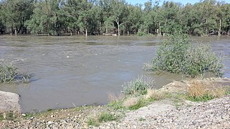
Burqin (river)
| Burqin | ||
|
Burqin River near Burqin |
||
| Data | ||
| location | Xinjiang ( PR China ) | |
| River system | Irtysh | |
| Drain over | Irtysh → Arctic Ocean | |
| Confluence of |
Kanas and Hemu 48 ° 30 ′ 17 ″ N , 87 ° 19 ′ 31 ″ E |
|
| Source height | 986 m | |
| muzzle |
Irtysh coordinates: 47 ° 42 ′ 25 " N , 86 ° 50 ′ 1" E 47 ° 42 ′ 25 " N , 86 ° 50 ′ 1" E
|
|
| length | approx. 150 km | |
| Medium-sized cities | Burqin | |
The Burqin ( Chinese 布尔津 河 ) is a right tributary of the Irtysh ( Ertix ) in the Kazakh Ili Autonomous District in the Xinjiang Uyghur Autonomous Region of the People's Republic of China .
It is formed at the confluence of Kanas (right) and Hom Chinese 禾木河 , Pinyin Hemu Hé (left) in the south of the Altai Mountains . It flows through the mountainous region in the Burqin district of the same name in the Altay administrative district in a predominantly southern direction. It is dammed by two dams. Finally it leaves the mountains and flows in the lower reaches in a south-westerly direction. It flows past the northwestern edge of the city of Burqin and flows on the right into the upper reaches of the Irtysh, which flows westwards.
The Burqin has a length of about 150 km. The Kanasi Lake is located in the catchment area of the Burqin .
Use of hydropower
There are two dams along the river, each with an attached hydropower plant.
The hydropower plants in the downstream direction:
| Surname | completion position |
Power in MW |
Dam height in m |
Storage space in million m³ |
|---|---|---|---|---|
| Chonghu'er | 2009 | 110 | 74 | 85 |
| Burqin Shankou | under construction | 220 | 95 | 221 |
