
Burrelton
|
Burrelton Scottish Gaelic Both Bhùirnich |
|||
|---|---|---|---|
 |
|||
| Coordinates | 56 ° 31 ′ N , 3 ° 18 ′ W | ||
|
|||
| Residents | 671 2011 census | ||
| administration | |||
| Post town | BLAIRGOWRIE | ||
| ZIP code section | PH13 | ||
| prefix | 01828 | ||
| Part of the country | Scotland | ||
| Council area | Perth and Kinross | ||
| British Parliament | Perth and North Perthshire | ||
| Scottish Parliament | Perthshire North | ||

Burrelton is a village in the Scottish Council Area Perth and Kinross and the traditional Scottish county of Perthshire . It is located about 16 km northeast of Perth and about 19 km west-northwest of Dundee . Burrelton borders directly on the neighboring village of Woodside . In 2011 Burrelton had 671 residents, an increase from 382 in 1961.
Burrelton lies between the Sidlaw Hills to the southeast and the River Tay to the north. It is connected to the trunk road network via the A94 which runs from Perth to Forfar . The closest towns along the road are Scone to the southwest and Coupar Angus to the northeast. The nearest airport is Perth Airport, about nine kilometers to the south-west . Burrelton was once connected to the rail network, but the station has since been abandoned.
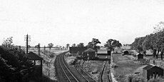
Former Burrelton Station in 1974
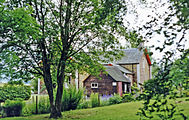
Station building 1997
_-_geograph.org.uk_-_1951329.jpg)

Individual evidence
- ^ Burrelton. Perth and Kinross. In: David Munro, Bruce Gittings: Scotland. An Encyclopedia of Places & Landscapes. Collins et al., Glasgow 2006, ISBN 0-00-472466-6 .
- ↑ Statistical data
- ↑ 2011 census
- ^ Burrelton. In: Francis H. Groome: Ordnance Gazetteer of Scotland: A Survey of Scottish Topography, Statistical, Biographical and Historical. Volume 1: (A - Coru). Thomas C. Jack, Grange Publishing Works, Edinburgh et al. 1882, p. 204 .