
Caibarién
| Caibarién | ||
|---|---|---|
|
Coordinates: 22 ° 30 ′ N , 79 ° 28 ′ W Caibarién on the map of Cuba
|
||
| Basic data | ||
| Country |
|
|
| City foundation | 1841 | |
| Residents | 33,485 (2012) | |
| Detailed data | ||
| surface | 335 km 2 | |
| Population density | 99.8 inhabitants / km 2 | |
| prefix | 53 - 42 | |
| Time zone | UTC -5 | |
 |
||

Caibarién is a city and a municipality in the province of Villa Clara in Cuba . It was founded in 1841. It became a community in 1876.
Caibarien is known as The White City for its white beaches . Also famous are the parades for the carnival , which is held together with the neighboring cities of Remedios and Camajuaní .
geography
The city is located on the north coast of Cuba and borders the beach of Bahia de Buena Vista ( “Bay of Good Visibility” ) on the Atlantic . It is located in the far east of the province of Villa Clara, near the province of Sancti Spíritus . It also has an airport .
Economy and tourism
In the past, the city served as a port for agricultural products such as sugar cane , tobacco, and fruit and vegetables . It also served as a fishing area for sponges . The hotels are now largely unusable due to the lack of maintenance. Many houses are in ruins. The landing stages in the port, originally used for agricultural products, have been destroyed. The two sugar mills, originally used to export sugar via the port, are now closed and derelict. The largest sugar refinery now serves as a museum.
The carnival takes place twice a year, once in August / September and again in mid-December, and each time lasts around two weeks.
The main tourist centers in Caibarien are the Cayos with Cayo Santa Maria , Cayo Fragoso , Cayo las Brujas etc.
Demographic data
In 2012 the municipality had a population of 33,485. With a total area of 335 km², it has a population density of 99.8 inhabitants per km².
Sons and daughters of the church
- Juan Bruno Tarraza (1912–2001), pianist and composer
See also

Less than a century ago, one of Cuba's busiest port cities. Much has fallen into disrepair these days
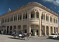
Former training center. Today it houses shops and the city's history museum.


Individual evidence
- ↑ Census 2012 (PDF; 257 kB), ONE
Web links
- Municipio Caibarién (Spanish)
- Pictures from Caibarién