Calea Victoriei
| Calea Victoriei Victory Road
|
|
|---|---|
| Street in Bucharest | |
| Hotel Continental (left) | |
| Basic data | |
| place | Bucharest |
| District | Victoriei |
| Created | 1692 |
| Hist. Names | Calea Brașovului, Podul Mogoșoaiei |
| Places | Piața Victoriei , Piața Națiunile Unite , Piața Revoluției , Piața George Enescu |
| Technical specifications | |
| Street length | 2700 m |
The Calea Victoriei ( German: Victory Road ) is a main thoroughfare in the historic city center of Bucharest in Romania . It connects Victory Square with the Piața Națiunile Unite and is 2700 meters long.
history
Calea Victoriei is one of the oldest main streets in Bucharest. At the time of Constantin Brâncoveanu's rule , the street was outside the city and was called Calea Brașovului ( Kronstadt Street ). The last part of the street (from Bulevardul Regina Elisabeta to Piața Națiunile Unite) was then called Ulița Mare spre Sărindar ( Great Street to Sărindar ), which led to the Sărindar Church , a church on which Cercul Militar was later built.
In 1692 the streets were connected by the ruler of Wallachia Constantin Brâncoveanu and renamed Podul Mogoșoaiei . The road was paved with tree trunks. Such roads were then called Pod (bridge), hence the name Podul Mogoșoaiei . The new road was built to directly connect the Voivod Palace Mogoșoaia with the old royal court .
Calea Victoriei became Bucharest's new main street and over time more and more boyar houses ( Conace ), churches, inns, and later hotels, shops, luxury shops, coffee houses and state institutions were built on it. At the time of the ruler Grigore Ghica , the street was paved with stones and in 1882 the city's first electric street lights appeared in front of the Royal Palace on Calea Victoriei.
Although the buildings differ in size and style and the socialist buildings changed the street unpleasantly, the Calea Victoriei became more and more important over time (since the 19th century it was also Königsstraße).
On October 8, 1878, when the Romanian army marched through the then still called Podul Mogoșoaiei main street to celebrate the victory against the Turks, it was renamed Calea Victoriei ( Victory Street ).
The name was retained during the socialist era, but was changed to Calea Victoriei Socialismului ( Road of Victory for Socialism ) in 1980 .
Buildings and monuments


- The National History Museum ( Postpalast ): The Postpalast was built between the years 1894–1900. The former state treasure, Tezaurul Național, has been located here since 1971 .
- Biserica Zlătari : The church is located next to the history museum . It was built in 1637 on the site of an old wooden church and later rebuilt by Mihai Cantacuzino in 1715 .
- Biserica Doamnei : The church is at the intersection between Calea Victoriei and Bulevardul Regina Elisabeta . It was founded in 1683 by Maria, the second wife of Șerban I. Cantacuzino .
- Grand Hôtel du Boulevard : Construction began in 1865 by the architect Alexander Orascu .
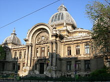
- CEC : It is opposite the National History Museum . The building was constructed in 1900 by the French architect Paul Gottereau .
- Cercul Militar : The military building is opposite the Grand Hôtel du Boulevard . It was designed in 1912 in the classic French style, by architects Dimitrie Maimarolu , Victor Stefanescu and Ernest Doneaud .
- Casa Capșa : It is in front of the Cercul Militar. The restaurant was built in 1881 and has been Bucharest's best restaurant for a century.
- Teatrul Odeon : The building is on the site of the old Costache Ghica house.
- Teatrul de revistă Constantin Tănase :
- Palatul Telefoanelor : The telephone palace was built in 1933 according to the plans of the American architects Louis Weeks and Walter Froy .
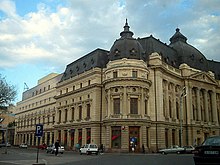
- Hotel Continental : The hotel is located at the intersection between Calea Victoriei and Strada Ioan Câmpineanu . It was planned by the architects Emil Ritten Forster and IIRasnovanu .
- The Macca-Villacrosse-Passagen : The shopping arcade was planned by the Catalan architect Xavier Vilacrosse .
- Biserica Crețulescu : The church was built in 1722 by Iordache Crețulescu and his wife, Safta, the daughter of Constantin Brâncoveanu.
- Monumentul Renașterii Naționale : It is located in the middle of the Revolution Square . It was built in 2005 by Alexandru Ghilduș .
- The National Art Museum ( Palatul Regal ): It is located on Piața Revoluției . The palace was built in 1937 according to the plans of the architect Nicolae Nenciulescu . Today, as an art museum, it houses paintings by Theodor Aman , Nicolae Grigorescu , Ion Andreescu , Ștefan Luchian , Theodor Pallady , Gheorghe Petraşcu , El Greco , Rembrandt , Rubens .
- Palace of the Senate : It is located on Piața Revoluției. First the building was the seat of the Council of Ministers, later the seat of the Central Committee of the PCR. Today it houses the Ministry of the Interior.
- The Central University Library : It is located opposite the art museum . The building was built in 1893 according to the plans of the architect Paul Gottereau .
- Hotel Athénée Palace ( Hilton ): It is located opposite the Romanian Athenaeum . The building was built between 1912–1914 according to the plans of the architect Théophile Bradeau .
- The Bucharest Athenaeum : It is located on Piața Revoluției. The building was built between 1886 and 1888 according to the plans of the architect Albert Galleron .
- Biserica Albă : The church was founded by the priest Neagu Dârvaș in the early 18th century. The interior frescoes were painted by Gheorghe Tattarescu .
- Muzeul Colecțiilor de Artă (Palatul Romanit): The building was erected in 1883 on the site of the old Romanit boyar house. Since 1978 it has housed the Museum of Art Collections.
- Muzeul Ceramicii și Sticlei ( Palatul Știrbei ): It was built in 1835 according to the plans of the architect Sanjouand .
- Uniunea Scriitorilor (formerly Monteru House ) was built according to the plans of the architect Nicolae Cuțarida .
- Casa Cesianu : It is located at the intersection between Calea Victoriei and Bulevardul Dacia and is the former German embassy in Bucharest.
- The Romanian Academy is located opposite the Cazino Victoria , in the former Cesianu boyar house .
- Biserica Sf. Nicolae Tabacu : The church is opposite the Romanian Academy and was built in the 17th century.
- Casa Vernescu : The building was built in 1820 by the Lenş family and later completely renovated by the architect Ion Mincu .
- The Cantacuzino Palace ( Muzeul Național "George Enescu" ): The building was built in the Rococo style between 1898 and 1900 according to the plans of the architect ID Berindei .
Former locations
- The Otetelişanu Terrace (today Palatul Telefoanelor)
- The "Kübler" coffee house (today the Cina restaurant)
- The "Fialkowski" coffee house
- The "High-Life" coffee house
- The old building of the TNB (now the Novotel )
- Sărindar Church (today Cercul Militar )
Web links
- Calea Victoriei - Flickr.com
- Rediscover Bucharest , Calea Victoriei (English)
- Povestea unei străzi , The story of a street (Romanian)
Coordinates: 44 ° 26 '36.9 " N , 26 ° 5' 34.1" E


