Canguçu
| Canguçu | ||
|---|---|---|
|
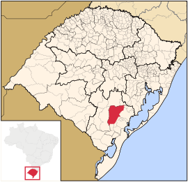
Coordinates: 31 ° 24 ′ S , 52 ° 41 ′ W Canguçu on the map of Rio Grande do Sul
|
||
| Basic data | ||
| Country | Brazil | |
| State | Rio Grande do Sul | |
| City foundation | June 27, 1857 | |
| Residents | 55,871 ( ber . 2018) | |
| City insignia | ||
| Detailed data | ||
| surface | 3,526,253 | |
| Population density | 15.11 inhabitants / km 2 | |
| height | 386 m | |
| Waters | Rio Camaquã | |
| Time zone | UTC −3 | |
| City Presidency | Cassio Luiz Freitas Mota ( PP ) | |
| Website | ||
| Location of Canguçu in Rio Grande do Sul | ||
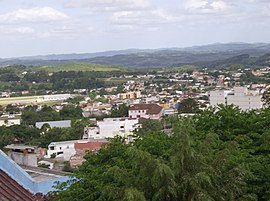
| Canguçu in the Serra dos Tapes | ||
Canguçu is a city with almost 56,000 (as of 2018) inhabitants in the state of Rio Grande do Sul in southern Brazil . It is located about 270 km southwest of Porto Alegre . The towns of Encruzilhada do Sul , Amaral Ferrador , Cristal , Cerrito , Morro Redondo , Pelotas , São Lourenço do Sul and Piratini are neighboring .
Sons and daughters
- Octaviano Pereira de Albuquerque (1866–1949), Roman Catholic clergyman, Bishop of Campos
See also
- Pomerano (minority language)
Web links
- IBGE to Canguçu. Retrieved June 30, 2019 .


