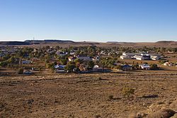
Carnarvon (South Africa)
| Carnarvon | ||
|---|---|---|
|
|
||
| Coordinates | 30 ° 56 ′ S , 22 ° 7 ′ E | |
| Basic data | ||
| Country | South Africa | |
| North Cape | ||
| District | Pixley Ka Seme | |
| ISO 3166-2 | ZA-NC | |
| local community | Kareeberg | |
| height | 1309 m | |
| Residents | 6612 (2011) | |
| founding | 1860 | |
| Website | www.carnarvon.co.za (English) | |
Carnarvon (formerly Harmsfontein ) is a town in the municipality of Kareeberg , Pixley Ka Seme District , Northern Cape Province in South Africa . It is located 135 kilometers northeast of Williston in the Karoo , at the intersection of roads R63 , R384 and R386 at an altitude of 1,309 meters above sea level. In 2011 it had 6,612 inhabitants.
history
Originally the area was roamed by the San centuries ago . However, from the end of the 18th century these were driven out by immigrant farmers - the Treckburen , the Baster , the Khoikhoi , the Koranna and the Xhosa .
Around 1850 there was conflict between some of these tribes here. The Rhenish Mission with Reverend Christoph Alheit took care of 110 refugees who were settled there. In 1860 a village called Harmsfontein was founded. The name was then changed to Carnarvon in 1874, after the British Colonial Secretary Henry Howard Molyneux Herbert (1831-1890), the Earl of Carnarvon. Carnarvon received town charter in 1882.
economy
Sheep breeding and hunting farms are the main sources of income.
Attractions
The North Cape Provincial Karoo is ideal for radio astronomy because it is sparsely populated, with minimal radio frequency interference from synthetic sources such as cell phones, TV, and air traffic. With the Square Kilometer Array (SKA) located near Carnarvon, the investigation of the first structures in the young universe in the frequency range from a few megahertz to gigahertz is to take place. Over 200 radio telescopes with an effective total area of one square kilometer will work in this facility . The SKA will be around a hundred times more sensitive than currently available instruments, which should significantly increase efficiency, especially in the area of surveys .
- Appie van Heerden Nature Reserve
- Karee Mountains
Web links
- City's website (English)
- South Africa Square Kilometer Array (English)
- Website of Carnarvon (English)
Individual evidence
- ^ Carnarvon, South Africa Page . Falling Rain Genomics, Inc .. Retrieved February 23, 2010.
- ↑ 2011 census , accessed November 18, 2013
- ↑ German Research Foundation (pdf; 5.6 MB)

