
Castilly
| Castilly | ||
|---|---|---|
|
||
| local community | Isigny-sur-Mer | |
| region | Normandy | |
| Department | Calvados | |
| Arrondissement | Bayeux | |
| Coordinates | 49 ° 16 ′ N , 1 ° 1 ′ W | |
| Post Code | 14330 | |
| Former INSEE code | 14142 | |

Castilly is a village at 464 meters above sea level in the French department of Calvados in Normandy . The formerly independent 12.20 km² community and today's commune Déléguée is located in the area of Canton of Trévières in Arrondissement of Bayeux and was a member of the municipal association Communauté de communes Isigny Grandcamp Intercom . It bordered on the north-west with Les Oubeaux , in the north with Vouilly , in the north-east with Colombières and Bricqueville , in the east with La Folie , in the south with Saint-Marcouf and Cartigny-l'Épinay , in the south-west with Lison and in the west with Neuilly-la -Forêt .
Until February 15, 1965, the municipality was called "Castilly-la-Forêt". It was incorporated into the Commune nouvelle Isigny-sur-Mer with effect from January 1, 2017 .
Population development
| year | 1962 | 1968 | 1975 | 1982 | 1990 | 1999 | 2008 | 2016 |
|---|---|---|---|---|---|---|---|---|
| Residents | 479 | 468 | 416 | 343 | 263 | 249 | 274 | 301 |
Attractions
- Castle of Castilly.
- Church Nativité de Notre-Dame
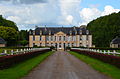
The Castle of Castilly

church
.JPG)
.JPG)