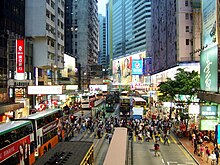
Causeway Bay
Causeway Bay or Tung Lo Wan ( Chinese 銅鑼灣 / 铜锣湾 , Pinyin Tóngluó Wān , Jyutping Tung 4 lo 4 Waan 1 / Tung 4 lo 4 Waan 1 * 4 ) is a district of Hong Kong on the north side of Hong Kong Island , known for its shopping opportunities is. In terms of average retail rents, Causeway Bay is the world's most expensive shopping arcade ahead of Fifth Avenue in New York for the second year in a row .
The district extends from Route 1 in the west to about Tin Hau Temple Road ( 天后 廟 道 / 天后 庙 道 , Tiānhòumiào Dào , Jyutping Tin 1 hau 6 miu 6 * 2 Dou 6 ) in the east. However, the limits are not officially set; administratively, Causeway Bay is predominantly part of the Wan Chai District . Kellett Island , Victoria Park and Tin Hau are part of the Eastern District .
Surname
The name "Causeway Bay" is derived from a dam ( English causeway ) that was heaped up in the former bay. The name "Tung Lo Wan" is a transcription of the Chinese place name ( 銅鑼灣 / 铜锣湾 ), which literally means "Copper Gong Bay". The "Tung Lo Wan Road" ( 銅鑼灣 道 / 铜锣湾 道 ) testifies to the use of transcription. Hong Kong-based Anglicist Michael Ingham names "Hung Heung Road" ( 紅 香 路 / 红 香 路 ) and Lily Street ( 蓮花 街 / 莲花 街 , Liánhuājiē , Jyutping Lin 4 faa 1 gaai 1 ) as other place names . The former refers to the nearby summit Hung Heung Lo Fung ( 紅 香爐峰 / 红 香炉峰 , Hóng Xiānglú Fēng , Jyutping Hung 4 Hoeng 1 lou 4 Fung 1 ) and literally means summit of the red censer . The name refers to the nearby "Lotus Temple" of the same name ( 蓮花 宮 / 莲花 宫 , Liánhuāgōng , Jyutping Lin 4 faa 1 gung 1 ) on Lily Street .
geography
A large part of the built-up area of today's Causeway Bay was created by reclamation in the former, muddy bay. The bay was between the headland East Point to the west and North Point to the east. The original course of the coast can be guessed from the course of the Tung Lo Wan Road. In 1884 the bay was reduced in size by filling an area of 9 hectares . Today's Causeway Road is located at the location of the piled-up dam that gives it its name . In the 1950s, a large area of land was raised on which Victoria Park was created. The island Kellett Iceland , just north of East Point, was initially linked by a causeway to Hong Kong Iceland. With the construction of the Cross Harbor Tunnel , opened in 1972 , Kellett Island was integrated into the coastline and is no longer an island. The original bay has also disappeared due to the land reclamation measures. On the coast is now the Causeway Bay Typhoon Shelter ( 銅鑼灣 避風塘 / 铜锣湾 避风塘 , Tóngluówān Bìfēngtáng , Jyutping Tung 4 lo 4 waan 1 at 6 fung 1 tong 4 ), a barrier to protect boats from typhoons . For the construction of the Central-Wan Chai Bypass , part of the Typhoon Shelters is to be temporarily drained in order to build an underwater tunnel .
Attractions
Causeway Bay is known for its many shopping malls. Some of the more famous include Times Square on Matheson Street, the World Trade Center on Gloucester Road, and Sogō on Hennessy Road. Other attractions are:
- Hong Kong Central Library
- Queen's College
- Noonday Gun
- Royal Hong Kong Yacht Club
- Victoria Park .
- Tin Hau Temple
traffic
The Island Line of the Mass Transit Railway stops at Causeway Bay Tube Station and Tin Hau . The Cross-Harbor Tunnel connects Causeway Bay with Hung Hom in Kowloon.
Web links
Individual evidence
- ^ Karsten Strauss: Hong Kong beats New York City . In: Forbes Magazine , November 15, 2013. Retrieved March 27, 2014.
- ↑ Michael Ingham: Hong Kong. A cultural history . Oxford University Press, Oxford et al. 2007, ISBN 0-19-531496-4 , pp. 72 .
- ^ R. Glaser, P. Haberzettl, RPD Walsh: Land Reclamation in Singapore, Hong Kong and Macau . In: GeoJournal . tape 24 , no. 4 , 1991, pp. 365-373 , JSTOR : 41145219 .
Coordinates: 22 ° 17 ' N , 114 ° 11' E

