
Centrala staden

Centrala staden is a district of the southern Swedish city of Lund with 13,202 inhabitants (2006).
The district with an area of 1.89 km² corresponds to the core city of Lund and is largely in the area of the medieval city wall . This is followed by areas north and south. Within the district lies the old town, including the university , the cathedral , Lund C train station , as well as the pedestrian zone, the Stortorget with the town hall, Bantorget with the Grand Hotel , Botulfsplatsen , Clemenstorget , Knut den Stores torg , Krafts torg , Mårtenstorget and the parks Stadsparken , Lundagård and Monumentparken .
Centrala staden tapers to a point in the north and borders with Monumentparken on Riksväg 16 and Norra Fäladen . In the east the border runs on the Allhelgona kyrkogata , Biskopsgatan and the Östra Vallgatan with a bend in the southeast on Dalbyvägen to the districts of Möllevången and Tuna . In the south, Centrala staden borders with the Ringvägen on the district Järnåkra-Nilstorp and southwest of the city park on the district Klostergården . In the west it is bounded by the Södra stambanan to Väster and Kobjer .
photos

The Lund Cathedral
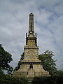
Monument parking : Helgo Zettervall's memorial to those who fell in the Battle of Lund


Web links
- Centrala staden (Swedish)
Individual evidence
- ↑ Lunds kommunkontor, Staben / Statistics ( Memento of the original from December 28, 2015 in the Internet Archive ) Info: The archive link was automatically inserted and not yet checked. Please check the original and archive link according to the instructions and then remove this notice. (PDF; 30 kB)
Coordinates: 55 ° 42 ' N , 13 ° 12' E