Cerro Pumiri
| Cerro Pumiri | ||
|---|---|---|
|
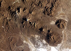
Cerro Pumiri (center right) next to Cerro Pariani (bottom right) (photo of ISS expedition 9 ) |
||
| height | 4852 m | |
| location | Oruro Department , Bolivia | |
| Mountains | To the | |
| Coordinates | 18 ° 59 ′ 51 " S , 68 ° 25 ′ 42" W | |
|
|
||
| Type | Stratovolcano | |
The Cerro Pumiri (also: Cerro Pumiri de Sabaya ) is a 4852 m high inactive stratovolcano in the South American Andes -State Bolivia .
The Cerro Pumiri located on the Bolivian Altiplano few kilometers north of Salt Lake Salar de Coipasa in the municipality of Sabaya in the province of Sabaya in Oruro Department . The Cerro Pumiri is adjacent to a chain of volcanoes that begins in the west with the Chilean volcano Isluga (5577 m) and extends over the triple summit of Cabaraya (5869 m) and Tata Sabaya (5385 m) to Cerro Pariani (5077 m) extends.
On the south-eastern edge of Cerro Pumiri are the village of Sabaya , the central place of the entire region north of the Salar de Coipasa.
Individual evidence
- ↑ Relief map of the Salinas de Garci-Mendoza region 1: 250,000 (PDF; 10.44 MB)
Web links
- Cerro Pumiri de Sabaya ( English )
- Relief map of the Salinas de Garci-Mendoza region 1: 250,000 (PDF; 10.44 MB)


