
Cete
| Cete | ||||||
|---|---|---|---|---|---|---|
|
||||||
| Basic data | ||||||
| Region : | Norte | |||||
| Sub-region : | Porto metropolitan area | |||||
| District : | postage | |||||
| Concelho : | Paredes | |||||
| Coordinates : | 41 ° 11 ′ N , 8 ° 21 ′ W | |||||
| Residents: | 3113 (as of June 30, 2011) | |||||
| Surface: | 4.68 km² (as of January 1, 2010) | |||||
| Population density : | 665 inhabitants per km² | |||||
| Postal code : | 4580-321 | |||||
| politics | ||||||
| Mayor : | Joaquim Tomás Fernandes Correira | |||||
| Address of the municipal administration: | Junta de Freguesia de Cete Rua de Fontielas, N.º 2 4580-321 Cete |
|||||


Cete (sometimes also Cête ) is a municipality ( freguesia ) in the Portuguese district ( concelho ) of Paredes . It has a population of 3113 (as of June 30, 2011).
history
In the 10th century there was already a monastery here, which was rebuilt at the end of the 11th century. The place that developed around the monastery belonged to the Aguiar de Sousa district . After its dissolution in 1855, Cete became a municipality in the Paredes district. In 2003 Cete received the status of a small town ( Vila ).
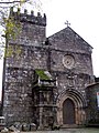
The Romanesque monastery church of Cete

The cloister of the monastery, 15th century

Front view of the monastery, 1905


Individual evidence
- ↑ a b www.ine.pt - indicator resident population by place of residence and sex; Decennial in the database of the Instituto Nacional de Estatística
- ↑ Overview of code assignments from Freguesias on epp.eurostat.ec.europa.eu
- ↑ www.monumentos.pt (under Cronologia ), accessed on February 8, 2014

Freguesias in the concelho Paredes