Ceylon (Minnesota)
| Ceylon | |
|---|---|
|
Location of Ceylon in Martin County and Minnesota
|
|
| Basic data | |
| Foundation : | 1899 |
| State : | United States |
| State : | Minnesota |
| County : | Martin County |
| Coordinates : | 43 ° 32 ′ N , 94 ° 38 ′ W |
| Time zone : | Central ( UTC − 6 / −5 ) |
| Residents : | 369 (as of 2010) |
| Population density : | 219.6 inhabitants per km 2 |
| Area : | 1.68 km 2 (approx. 1 mi 2 ) of which 1.68 km 2 (approx. 1 mi 2 ) is land |
| Height : | 384 m |
| Postal code : | 56121 |
| Area code : | +1 507 |
| FIPS : | 27-10792 |
| GNIS ID : | 641085 |
| Mayor : | John Gibeau |
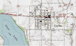
 Topographic map of Ceylon and environs |
|
Ceylon is a city in Martin County in the US state of Minnesota . At the time of the 2010 United States Census , Ceylon had 369 residents. The place was founded around 1900 and is known as the birthplace of Walter Mondale .
geography
According to the United States Census Bureau , the city has an area of 1.68 km², excluding land.
Ceylon is east of Clear Lake in the Lake Belt Township and has an irregularly shaped, yet almost square urban area on Minnesota State Route 263 in Minnesota's 1st congressional electoral district . The area is located in the northern part of the catchment area of the East Fork Des Moines River and thus drains to the Gulf of Mexico .
supporting documents
- ↑ US Gazetteer files 2010 ( English ) United States Census Bureau . Archived from the original on February 20, 2011. Retrieved November 13, 2012.
