
Chagang-do
| Chagang-do | |
|---|---|
| Chosŏn'gŭl : | 자강도 |
| Hancha : | 慈 江 道 |
| McCune-Reischauer : | Chagang-do |
| Revised Romanization : | Jagang-do |
| Basic data | |
| Surface: | 16,613 km²
|
| Residents: | 1,147,946 (as of January 1, 2005) |
| Population density : | 69 inhabitants per km² |
| Structure : |
3 cities ( Si ); 15 counties ( Kun ) |
| Administrative headquarters : | Kanggye |
  |
|

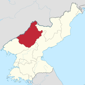
Chagang-do is a province in North Korea . The seat of government of Chagang-do Province is in Kanggye .
history
Chagang was created in 1949 by splitting off the eastern part of the P'yŏngan-pukto province and part of the Hamgyŏng-namdo province . The name of Chagang is made up of the first syllables of the two cities Chasŏng and Kangye.
geography
Chagang-do borders in the north on the People's Republic of China , in the east on Ryanggang-do and Hamgyŏng-namdo , in the south on P'yŏngan-namdo and in the west on P'yŏngan-pukto .
The province of Chagang is 98% mountainous, the average altitude is 804 meters, with the eastern part being far higher than the western part. Chagang-do is traversed by the Nangrim Mountains in a north-south direction . In an east-west direction, the Kangnam Mountains run parallel to the Yalu river border with the People's Republic of China . The Jeokyryeong Mountains also run through the province in an east-west direction. In the northwest of the Nangrim Mountains is the 1227 high mountain Oga with a jungle and a nature reserve that has existed since 1959.
Next to the Yalu are the Changja-gang (third tributary of the Yalu), the Wiwon , the Chasŏng and the Chongchon . The latter rises from the 1003 meter high Gaphyeon mountain and flows through Kujang-kun , Kaechon and Anju before flowing into the Yellow Sea . 152 kilometers of 217 kilometers are navigable.
economy
Chagang-do is a center for the arms and ammunition industry with its locations in Hŭich'ŏn and Kanggye . Several hydropower plants have been built on the rivers of the province, the largest of which, the Unbong (400 MW, commissioned in 1970) and Wiwon (400 MW, commissioned in 1990), were built in cooperation with China. In addition, there are numerous small and micro hydropower plants, for which Chagang was the model province. Of the resulting reservoirs, the Supung reservoir is the largest.
Administrative division
Several territorial reforms were carried out in the 1950s. Since then, Chagang-do Province has been divided into three cities and 15 counties:
Cities
Counties
- Changgang-kun ( 장강 군 ; 長江 郡 )
- Chasŏng-kun ( 자성군 ; 慈城 郡 )
- Chŏnch'ŏn-kun ( 전천군 ; 前 川 郡 )
- Ch'osan-kun ( 초산 군 ; 楚 山 郡 )
- Chunggang-kun ( 중강 군 ; 中 江 郡 )
- Hwap'yŏng-kun ( 화평 군 ; 和 坪 郡 )
- Kop'ung-kun ( 고풍 군 ; 古 豐 郡 )
- Rangrim-kun ( 랑 림군 ; 狼 林 郡 )
- Ryongrim-kun ( 룡 림군 ; 龍 林 郡 )
- Shijung-kun ( 시중 군 ; 時 中 郡 )
- Sŏnggan-kun ( 성간 군 ; 城 干 郡 )
- Songwŏn-kun ( 송원 군 ; 松原 郡 )
- Ushi-kun ( 우 시군 ; 雩 時 郡 )
- Wiwŏn-kun ( 위원 군 ; 渭 原 郡 )
- Tongsan-kun ( 동신 군 ; 東 新 郡 )
Web links
Individual evidence
- ↑ a b c d e Yonhap News Agency (ed.): North Korea handbook . Sharpe, Armonk, NY 2003, ISBN 0-7656-1004-3 , pp. 73-76 .
Cities centrally administered by the Pyongyang government
Special administrative
regions Kaesŏng industrial region |
Tourist region Kŭmgang-san |
Special administrative region Sin Besondereiju
Chagang-do provinces |
Hamgyŏng-pukto |
Hamgyŏng-namdo |
Hwanghae-pukto |
Hwanghae-namdo |
Kangwon-do |
P'yŏngan-pukto |
P'yŏngan-namdo |
Ryanggang-do
Coordinates: 41 ° 0 ' N , 126 ° 30' E