
Chalasmenos

Chalasmenos ( Greek Χαλασμένος ), also Chalasmeno , is an archaeological excavation site in the northeast of the Greek island of Crete . It is located in the municipality of Ierapetra in the Lasithi regional district, about 600 meters northeast of the village of Monastiraki . The remains of the settlement exposed at an altitude of 230 meters in front of the exit of the Cha Gorge date from the late Minoan period at the end of the 2nd millennium BC. Chr.
history
Chalasmenos is about 3.35 kilometers as the crow flies from the north coast of Crete near Pachia Ammos . Another Minoan settlement was discovered 350 meters northeast of the excavation site, Katalymata (Καταλύματα). The latter on the northern slope of the exit of the Cha Gorge is regarded as the predecessor settlement of Chalasmenos. The finds from Katalymata come from different epochs, while Chalasmenos was mostly only settled in the SM III C section of the late Minoan period, the early Iron Age or dark centuries . During this phase, Chalasmenos was one of the largest settlements in the northern area of the isthmus of Ierapetra. Systematic excavations began in 1992 under the direction of Metaxia Tsipopoulou and William Coulson .

The excavation site consists of three sectors with an open, roughly square square in the center. A total of five megarons have been excavated, with evidence of a sixth megaron. A megaron is a type of house with a rectangular floor plan with a main room, usually with a stove, and an anteroom. Three of the Megara were lined up in parallel in the northern part of Sector A in the west of the settlement. The other houses of Chalasmenos in Sector B in the southeast and Sector C in the northeast were built in a row. The only almost free-standing building was the 5.5 × 13 meter shrine of the "Goddesses with the raised arms" in the north. A similar one can be found in the excavation of Vronda (Βρόντα) near Kavousi . In the late Geometric period (6th century BC) a farm building called Oikos was built in the southeast of the southern megaron in Sector A of Chalasmenos, which bordered the central square of the settlement.
The combination of two architectural styles in Chalasmenos, the lined-up Minoan construction with the shape of the Mycenaean megaron, led the excavation manager Metaxia Tsipopoulou to the thesis that the settlement could have been inhabited by a population of mixed ethnic origins. A similar mix of styles from this period can also be found in the hillside settlement of Karphi (Καρφί). The Mycenaean ceramics of the finds comprised about 57% of the preparation of food, 26% for their ingestion and 17% for storage and less than 1% of specialized vases. Despite the late Geometric oikos on and next to the largest megaron of the settlement, the excavation site of Chalasmenos represents a largely undisturbed finding from the late Minoan period III C.
- Excavation site
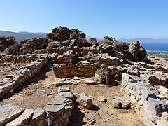
House 2 in sector B

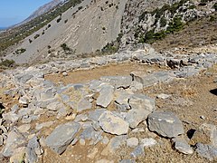
Southern area of Sector A
Sector C

Shrine of the "goddesses with their hands raised"


literature
- Metaxia Tsipopoulou: Chalasmenos, Ierapetra: "Mycenaeanizing" or Not at the End of the Bronze Age . In: Kevin T. Glowacki, Natalia Vogeikoff-Brogan (Ed.): Στέγα: The Archeology of Houses and Households in Ancient Crete (= Hesperia Supplement . Volume 44 ). American School of Classical Studies at Athens, 2011, p. 333–347 (English, digitized version ).
Individual evidence
- ^ S. Paragamian, K. Paragamian: Ha Gorge. Exploring a spectacular hidden landscape. Hellenic institute of speleological research, Heraklion 2015, ISBN 978-618-82232-1-9 , pp. 26-27 ( online ).
- ↑ Krzystof Nowicki: Monastiraki Katalimata and Cretan History . In: Monastiraki Katalimata: Excavation of a Cretan Refuge Site, 1993-2000 . INSTAP Academic Press, Philadelphia 2008, ISBN 978-1-931534-24-6 , pp. 85 (English, digitized version ).
- ^ Krzysztof Nowicki: Settlement in Crisis: The End of the LM / LH IIIB and Early IIIC in Crete and Other South Aegean Islands . In: A. Mazarakis Ainian (Ed.): The "Dark Ages" Revisited. Acts of an International Symposium in Memory of William DE Coulson . University of Thessaly, Volos 2011, p. 442 (English, digitized version ).
- ↑ a b c d Anastasia Christophilopoulou: Domestic Space and Community Identity in the Aegean Islands and Crete 1200–600 BC . In: Maria Kristina Lahn, Maren-Grischa Schröter (Hrsg.): Raumdimimen im Altertum (= MOSAIKjournal . Volume 1 ). Aegeus Society for Aegean Prehistory, 2010, ISBN 978-1-61143-955-7 , Chalasmenos, p. 91-97 (English, PDF; 2986.99 KB ).
- ^ Metaxia Tsipopoulou: A New Late Minoan IIIC Shrine at Halasmenos, East Crete . In: Robert Laffineur, Robin Hägg (Ed.): POTNIA. Deities and Religion in the Aegean Bronze Age (= Aegaeum . Band 22 ). Université de Liège, Liège 2001, p. 99 (English, digitized version ).
- ↑ David Rupp: Monastiraki Katalimata. Excavation of a Cretan Refuge Site, 1993-2000 (review) . In: Mouseion: Journal of the Classical Association of Canada . tape 8 , no. 2 , 2008, p. 296-298 (English, online ).
- ^ Metaxia Tsipopoulou: The economics of monumental buildings: A View from Crete . In: Parallel Lives: Ancient Island Societies in Crete and Cyprus (= British School at Athens Studies . Volume 20 ). British School at Athens, 2012, p. 216–217 (English, PDF; 1884.62 KB ).
- ^ Krzysztof Nowicki: From Late Minoan IIIC Refuge Settlements to Geometric Acropoleis . In: Jean-Marc Luce (ed.): Habitat et urbanisme dans le monde grec de la fin des palais mycéniens à la prize de Milet . Presses Universitaires du Mirail, Toulouse 2002, ISBN 2-85816-622-6 , p. 168 (English, digitized version ).
Web links
- Chalasmenos - KAS 99. In: Digital Crete: Archaeological Atlas of Crete. Foundation for Research and Technology-Hellas (FORTH), Institute for Mediterranean Studies(English).
- Chalasmeno. (PDF) Location and plan. Heidelberg University, accessed on December 28, 2016 .
- Matthew Haysom: Chalasmenos. American School of Classical Studies at Athens, August 11, 2014, accessed March 5, 2018 .
Coordinates: 35 ° 5 ′ 1.5 ″ N , 25 ° 49 ′ 53.9 ″ E