Chambord (Quebec)
| Chambord | ||
|---|---|---|
 Val Jalbert in Chambord |
||
| Location in Quebec | ||
|
|
||
| State : |
|
|
| Province : | Quebec | |
| Administrative region : | Saguenay – Lac-Saint-Jean | |
| MRC or equivalent : | Le Domaine-du-Roy | |
| Coordinates : | 48 ° 26 ′ N , 72 ° 4 ′ W | |
| Area : | 157.03 km² | |
| Residents : | 1690 (as of 2006) | |
| Population density : | 10.8 inhabitants / km² | |
| Time zone : | Eastern Time ( UTC − 5 ) | |
| Postal code : | G8H | |
| Area code : | +1 418 | |
| Website : | www.chambord.ca | |
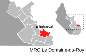
 Location of Chambord in Le Domaine-du-Roy MRC (French municipalité régionale du comté): regional county municipality |
||
Chambord is a municipality ( Municipalité ) in the MRC Le Domaine-du-Roy in the Canadian province of Québec .
The place is on the south bank of Lac Saint-Jean between the mouths of the two rivers Métabetchouane (in the east) and Ouiatchouan (in the west).
In 2006 Chambord had a population of 1,690.
The 2010 open water world championships were held in Chambord .
Web links
Commons : Chambord - collection of images, videos and audio files
Individual evidence
- ^ Commission de toponymie du Québec: Chambord
- ↑ [1] ( Page no longer available , search in web archives ) Info: The link was automatically marked as defective. Please check the link according to the instructions and then remove this notice.
