Chamlang
| Chamlang (west summit) | ||
|---|---|---|
|
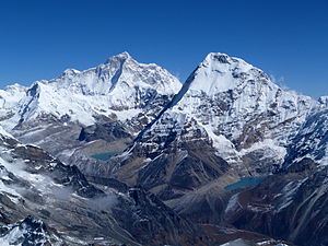
The wide south face of Chamlang (front right, main summit at the left end of the ridge) appears small compared to the Nuptse - Lhotse south face behind it , which Mount Everest still towers above in the center of the picture . |
||
| height | 7319 m | |
| location | Solukhumbu District , Sankhuwasabha ( Nepal ) | |
| Mountains | Mahalangur Himal ( Himalaya ) | |
| Dominance | 16.35 km → Makalu - Southeast Summit | |
| Notch height | 1193 m | |
| Coordinates | 27 ° 46 '32 " N , 86 ° 58' 48" E | |
|
|
||
| First ascent | May 31, 1962 by a Japanese expedition | |
|
Southwest face of the Chamlang, left behind the Makalu |
||
The Chamlang is a mountain in the Mahalangur Himal in Nepal near the Makalu . The Chamlang has a mountain ridge that is over 6 km long in a north-northeast direction and has only slight differences in altitude. The highest point is the 7,319 m high west summit at the western end of the mountain ridge. There is also a 7,180 m high central summit ( ⊙ ) and a 7,235 m high east summit ( ⊙ ). Along the northern flank of the ridge, the Chamlang Glacier flows in an easterly direction and flows below the northeast flank into the Lower Barun Glacier . The Isuwa Glacier runs south of Chamlang in an easterly direction. East of the Chamlang, the ridge is continued in the peaks Turtse ( Peak 6 ) and Peak 7 . To the west of the Chamlang, the Hunku Drangka river valley runs south. There are two glacial lakes at the western foot of the Chamlang .
Ascent history
The mountain was first climbed on May 31, 1962 by the Japanese Soh Anma and the Indian Sirdar Pasang Phutar III as part of the Hokkaido University Mount Chamlang Expedition . The ascent route led from the glacier to the west over the south ridge to the summit.
On May 16, 1984, a group of climbers consisting of Jean Afanassieff, Doug Scott and Michael Scott and the Nepalese Ang Phurba succeeded in making the first ascent of the eastern and central peaks. They reached the eastern summit via the north wall and the northeast ridge. Then they followed the ridge to the central summit.
Web links
- Chamlang, Nepal on Peakbagger.com (English)
- Chamlang East, Nepal on Peakbagger.com (English)
- Chamlang at Peakware (English)


