
Chartreuse de la Verne


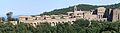
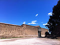
The Chartreuse de la Verne is a former Charterhouse between the towns of Cogolin and Collobrières in the Var department in southern France . Surrounded by huge protective and retaining walls, it lies like a bulwark near a spring on a plateau-like mountain ledge (415 m high) in a lonely forest landscape in the middle of the Mauren massif .
The important monastery complexes from the 12th to 18th centuries are currently being extensively restored thanks to the active support of the “Association des Amis de la Verne” (Friends of the Chartreuse de la Verne). With the reconstruction of the monks' cells and the first Romanesque church as well as other parts of the building, the restoration work has now entered a decisive phase (2006).
sightseeing
The winding and narrow road (D214) can now be used up to the Charterhouse. The facility can be visited except on Tuesdays. In January the monastery is closed on the occasion of the "fermeture annuelle". The services can be attended.
history
The Charterhouse was built in 1170 on the initiative of the bishops of Toulon ( Pierre Isnard ) and Fréjus ( Fredol d'Anduze ) by Carthusian monks from the Grande Chartreuse near Grenoble in the midst of dense chestnut forests on the site of an abandoned priory of the same name; the church was dedicated to the Virgin Mary on October 3, 1174. Thanks to many donations and additional acquisitions, the Charterhouse soon came into possession of over 3,000 hectares of land (forest, meadows, fields).
Although the system burned down completely in 1214, 1271 and 1318, it was always rebuilt. The Carthusians were often exposed to attacks: looters, neighboring feudal lords, Saracens and Protestants (1577) devastated the complex. Numerous building activities of the Carthusian monks from the 18th century are also evidenced by the dates carved into various components: 1738, 1772, 1789. During the French Revolution , the complex fell to the state in 1790, the last monks fled, and the entire property became in 1792 auctioned.
It was not until January 18, 1921 that the former Charterhouse was recognized as a "Monument Historique" (historical monument). On March 1, 1961, it became the property of the Administration des Eaux et Forêts (State Forestry Administration).
The “Association des Amis de la Verne” was established in 1968 to maintain and restore the Charterhouse. Members of the Monastic Family of Bethlehem, the Assumption of Mary and St. Bruno have lived there since 1983 .
In 2000 the restoration and rebuilding of the large cloister and the church took place.
Building description
Little remains from the Romanesque period: some remains of the church and the sacristy. Most of the structures still in existence date back essentially to the 17th and 18th centuries. In addition to their dimensions and the closed character of their overall appearance, the existing stone carvings (portals, door gables, door and window frames, arcades ...) made of serpentine , the green stone of the Maures massif, are particularly eye-catching; In connection with this marble-like stone, the slate walls create the effect of polychromy .
The high, fortress-like front of the Charterhouse is broken through by the main entrance - a magnificent portal structure with a gable and columns made of serpentine stone.
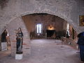
This entrance leads to the first, the southernmost part of the entire complex, which is called "Lower House". Here were the converse (lay brothers) and Familiares (staff of the monastery), the workers and any visitors accommodated. In this part there is now the new, small entrance with reception hall and exhibition rooms as well as the former barn, bakery, oil mill, store and cellar; The visitor chapel in the former kitchen rooms can also be found here.
The middle part is the area with the buildings of monastic community life: u. a. the Romanesque church (restoration work!) from the 12th century, the church from the 17th century and the remains of the small cloister from the 12th to 17th centuries.
The third and northernmost part is the large “cloister of solitude”, laterally bounded by the cells with their little gardens - the actual living area of the priests (monks). In the inner courtyard of the cloister is also the Carthusian cemetery, where around 800 monks found their final resting place between the 12th century and the French Revolution.
Exterior view

Entrance to the monastery complex
One of the interiors

Abbot's lodging with a garden

Abbot quarters
front


Individual evidence
- ↑ Chartreuse de la Verne on bastianwehler.de.Retrieved on September 24, 2010
- ↑ Official website of the Catholic Church in the Var department. Accessed September 24, 2010 (French)
Web links
Coordinates: 43 ° 14 '8.4 " N , 6 ° 24' 4.6" E