Chinko (river)
| Chinko | ||
|
Chinko in the Central African Republic |
||
| Data | ||
| location |
|
|
| River system | Congo | |
| Drain over | Mbomou → Ubangi → Congo → Atlantic | |
| source | On the border with Sudan 8 ° 16 ′ 33 ″ N , 24 ° 15 ′ 40 ″ E |
|
| Source height | 902 m | |
| muzzle | in Mbomou coordinates: 4 ° 49 ′ 57 " N , 23 ° 53 ′ 12" E 4 ° 49 ′ 57 " N , 23 ° 53 ′ 12" E |
|
| Mouth height | 516 m | |
| Height difference | 386 m | |
| Bottom slope | 0.59 ‰ | |
| length | 658 km | |
| Discharge at the Rafai gauge (1749550) A Eo : 52,500 km² Location: about 30 above the mouth |
NNQ (Feb 1957) MNQ MQ Mq MHQ HHQ (Oct 1955) |
8 m³ / s 55.7 m³ / s 397 m³ / s 7.6 l / (s km²) 1098 m³ / s 1790 m³ / s |
The Chinko is a river in the Central African Republic .
course
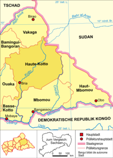
The right tributary of the Mbomou rises in the east of the Central African Republic, right on the border with South Sudan . It forms most of the border between the two prefectures of Haute-Kotto and Haut-Mbomou . The information about its length is different. They are put at 658 km and around 450 km.
Hydrometry
Average monthly flow of the Chinko measured at the hydrological station in Rafai, 22 km above the confluence with the Mbomou in m³ / s (1952–1973).

