Chippewa River (Mississippi River)
| Chippewa River | ||
|
Chippewa River at Eau Claire |
||
| Data | ||
| Water code | US : 1578997 | |
| location | Wisconsin (USA) | |
| River system | Mississippi River | |
| Drain over | Mississippi River → Gulf of Mexico | |
| origin |
Lake Chippewa 45 ° 53 ′ 18 " N , 91 ° 4 ′ 37" W. |
|
| Source height | 400 m | |
| muzzle |
Mississippi River Coordinates: 44 ° 24 '33 " N , 92 ° 5' 3" W 44 ° 24 '33 " N , 92 ° 5' 3" W. |
|
| Mouth height | 203 m | |
| Height difference | 197 m | |
| Bottom slope | 0.67 ‰ | |
| length | 294 km | |
| Left tributaries | Thornapple River , Flambeau River , Jump River , Yellow River , Eau Claire River , Eau Galle River | |
| Right tributaries | Couderay River , Red Cedar River | |
| Reservoirs flowed through | Lake Chippewa , Lake Holcombe , Lake Wissota | |
| Medium-sized cities | Eau Claire | |
| Small towns | Chippewa Falls | |
| Communities | Cornell , Durand | |
|
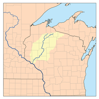
Course and catchment area of the Chippewa River |
||
The Chippewa River is a left tributary of the Mississippi River in the US state of Wisconsin .
The Chippewa River arises at the confluence of its two headwaters, East Fork Chippewa River and West Fork Chippewa River . The river is dammed up to Lake Chippewa at this point . The Chippewa River flows in a predominantly south-southwest direction through northwest Wisconsin. He passes the city of Eau Claire . Other places along the river are Chippewa Falls , Cornell and Durand . Finally, the Chippewa River flows into the Mississippi River on the left. The Chippewa River has a length of 294 km.
Brunet Island State Park is located on the middle reaches of the Chippewa River near Cornell . The Five-Mile Bluff Prairie State Natural Area and Nelson-Trevino Bottoms State Natural Area are located on the eastern bank of the Chippewa River just before it flows into the Mississippi River .

