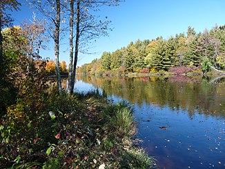
Flambeau River
|
Flambeau River North Fork Flambeau River |
||
|
Flambeau River in the Flambeau River State Forest |
||
| Data | ||
| Water code | US : 1579255 | |
| location | Wisconsin (USA) | |
| River system | Mississippi River | |
| Drain over | Chippewa River → Mississippi River → Gulf of Mexico | |
| Confluence of |
Manitowish River and Bear River 46 ° 4 ′ 34 " N , 90 ° 1 ′ 47" W |
|
| Source height | 480 m | |
| muzzle |
Chippewa River Coordinates: 46 ° 4 ′ 34 " N , 90 ° 1 ′ 47" W 46 ° 4 ′ 34 " N , 90 ° 1 ′ 47" W. |
|
| Mouth height | 320 m | |
| Height difference | 160 m | |
| Bottom slope | 0.8 ‰ | |
| length | 200 km | |
| Catchment area | 4820 km² (13 km above the mouth) | |
| Discharge at the Bruce A Eo gauge : 4820 km² Location: 13 km above the mouth |
MQ 1952/2016 Mq 1952/2016 |
50 m³ / s 10.4 l / (s km²) |
| Left tributaries | South Fork Flambeau River | |
| Reservoirs flowed through | Turtle-Flambeau Flowage , Pixley Flowage, Crowley Flowage 802, Big Falls Flowage, Dairyland Reservoir, Thornapple Flowage 1965 | |
| Small towns | Park Falls , Ladysmith | |
| Communities | Thornapple | |
| South Fork Flambeau River | ||
| Water code | US : 1580457 | |
| location | Wisconsin (USA) | |
| River system | Mississippi River | |
| Drain over | Flambeau River → Chippewa River → Mississippi River → Gulf of Mexico | |
| origin |
Round Lake 45 ° 55 ′ 34 " N , 90 ° 4 ′ 38" W. |
|
| Source height | 472 m | |
| muzzle | Flambeau River 45 ° 38 ′ 48 " N , 90 ° 47 ′ 38" W. |
|
| Mouth height | 390 m | |
| Height difference | 82 m | |
| Bottom slope | 0.82 ‰ | |
| length | 100 km | |
| Discharge at the Phillips A Eo gauge : 1577 km² Location: 20 km above the mouth |
MQ Mq |
17 m³ / s 10.8 l / (s km²) |
| Left tributaries | Elk River | |
| Right tributaries | Springstead Creek | |
| Communities | Fifield | |
The Flambeau River (also known as the North Fork Flambeau River in the upper reaches ) is a 200 km long left tributary of the Chippewa River in the US state of Wisconsin .
The Flambeau River arises at the confluence of the Manitowish River and Bear River in northern Wisconsin. It is dammed up at the beginning of the Turtle-Flambeau Flowage . It then flows in a predominantly south-westerly direction. He passes the small town of Park Falls . It then flows through the Pixley Flowage and Crowley Flowage 802 reservoirs . The middle reaches of the Flambeau River is in the Flambeau River State Forest . 77 km above the mouth, the Flambeau River joins the South Fork Flambeau River. Other reservoirs on the lower reaches are Big Falls Flowage , Dairyland Reservoir and Thornapple Flowage 1965 . In its lower reaches, the Flambeau River passes the small town of Ladysmith and the village of Thornapple before it meets the Chippewa River just under 60 km north-northeast of Eau Claire . The Flambeau River drains an area of about 4820 km². The mean discharge is 50 m³ / s. The highest monthly discharges usually occur in April and May.
The Flambeau River is considered a popular canoeing water.
South Fork Flambeau River
The South Fork Flambeau River is a 100 km long left tributary of the Flambeau River in Wisconsin. Except for the last few miles, the river is entirely within Price County . The South Fork Flambeau River has its origin in Round Lake . It initially flows west. It turns southwest about 3 miles east of Park Falls. He passes the village of Fifield . The South Fork Flambeau River eventually flows into the Flambeau River. The river is without a dam on its flow path.
Web links
- North Fork Flambeau River Watershed at Dept. for Natural Resources (PDF, 976 KB)
Individual evidence
- ↑ Manitowish River in the United States Geological Survey's Geographic Names Information System
- ↑ a b Flambeau River in the Geographic Names Information System of the United States Geological Survey
- ↑ a b c USGS 05360500 FLAMBEAU RIVER NEAR BRUCE, WI
- ↑ Round Lake in the Geographic Names Information System of the United States Geological Survey
- ↑ South Fork Flambeau River in the Geographic Names Information System of the United States Geological Survey
- ↑ USGS 05359500 SOUTH FORK FLAMBEAU RIVER NEAR PHILLIPS, WI
