Christiana (Jamaica)
| Christiana | ||
|---|---|---|
|
|
||
| Coordinates | 18 ° 10 ′ 29 ″ N , 77 ° 29 ′ 28 ″ W | |
| Basic data | ||
| Country | Jamaica | |
| county | Middlesex | |
| Manchester | ||
| ISO 3166-2 | JM-12 | |
| height | 825 m | |
| surface | 2.2 km² | |
| Residents | 8430 (2011) | |
| density | 3,920.9 Ew. / km² | |
|
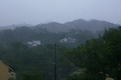
Christiana in 2007
|
||
Christiana is a small town in inland Jamaica . The city is located in County Middlesex and is the second largest city in the Manchester Parish . In 2011 Christiana had a population of 8,430 people.
geography
Christiana is a location in the May Day Mountains and averages 825 meters above sea level. The place is surrounded by a gentle hilly landscape that alternates with extremely fertile valleys, most of which are cultivated and used for agriculture.
The closest settlement is Sedburgh, about 3 kilometers south, and its neighboring town of Clandon . In the north, about 4 kilometers away, are the small villages of Dump , Hansons and Moravia, which is about the same distance but further east . Christiana is about 14 kilometers from Mandeviele , the capital and largest settlement of the Manchester Parish.
history
Christiana was first settled by German farmers between the 18th and 19th centuries. Christian missionaries of the Moravian Brethren were particularly active in this region . In the city there are mainly churches of this religious community. In the 19th century Christiana was especially popular with the European nobility and money nobility as a vacation spot. Today, the residents of Kingston in particular use the place as a destination, which is known for its moderate temperatures.
In 2007, Hurricane Dean hit the city. It flooded most of the streets and uprooted trees.
Culture and environment
Churches
In addition to the dominant religious community of the Moravian Brethren , there are also other churches and monasteries of the Sacred Heart Church and a religious community of Bobo Ashanti and the United Church of Christ .
nature
The nearby Gourie Cave is one of around 100 caves in Parish and at 3,505 m the longest known cave system in Jamaica.
sons and daughters of the town
- Delroy Chuck , lawyer and politician of the Jamaica Labor Party (JLP)
- Byron Lee , musician
- Audley Shaw , JLP politician
See also
Individual evidence
- ^ Population and Housing Census 2011 Jamaica. (No longer available online.) In: http://jamaica-gleaner.com/ . Gleaner Company Ltd., 2012, archived from the original on October 12, 2014 ; accessed on August 25, 2014 . Info: The archive link was inserted automatically and has not yet been checked. Please check the original and archive link according to the instructions and then remove this notice.
- ↑ Brief description on TravelInformation.com

