
Clinton-Kalamazoo Canal
| Clinton-Kalamazoo Canal | |||
|---|---|---|---|
| National Register of Historic Places | |||
 Remnants of the Clinton-Kalamazoo Canal in Macomb County |
|||
|
|||
| location | from Clinton Township to Rochester , Michigan , United States | ||
| Coordinates | 42 ° 39 '17 " N , 83 ° 3' 10" W | ||
| Built | 1838 | ||
| NRHP number | 72000638 | ||
| The NRHP added | March 24, 1972 | ||

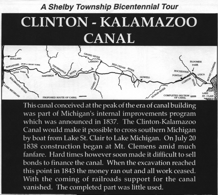
The Clinton-Kalamazoo Canal is a partially completed Michigan canal that was never operational. The canal was supposed to connect Lake St. Clair with Lake Michigan . The inspiration for the canal construction came from the success of the Erie Canal in New York, which was completed in 1825. In 1837 Michigan became a state and its first governor , Stevens Mason , started an ambitious project that included B. included infrastructural improvements, including three railway lines and two canals.
The Clinton-Kalamazoo Canal was to begin in Mount Clemens , on the banks of the Clinton River and run through Utica , Rochester , Pontiac , Howell and Hastings to the mouth of the Kalamazoo River . The total length should be 348 km (216 miles ). It should be able to bring new settlers and supplies into the interior of the new state and establish the connection to the town of Singapore on the shores of Lake Michigan, which was founded in 1836. Singapore should be able to carry passengers and cargo across Lake Michigan to Chicago.
Construction began in 1838 with great public interest. Financial problems due to the panic of 1837 meant that funding for the project stalled and all construction work stopped in 1838 after only 19 km had been completed. Further reasons for the failure of the construction were the incorrect calculations of the engineers; so the canal was built too shallow and narrow for heavy cargo ships.
After construction was stopped, the construction phase quickly fell into disrepair. Parts of the canal were used as mill ditches, which worked well into the 20th century. Remnants of the canal are still visible in Rochester Hills , Oakland County , and in Shelby Charter Township and Clinton Charter Township , Macomb County .
Web links
- Clinton-Kalamazoo Canal , Michigan Historical Marker Web Site (Jim Brennan, michmarkers.com).
- Clinton-Kalamazoo Canal , Shelby Township Historical Committee.
- The Clinton-Kalamazoo Canal , Mount Clemens Public Library, 2008.
- The Clinton & Kalamazoo Canal , Clinton Township Historical Commission.
- Steve Wilke: Big Plans: When Erie Canal Envy Got Michigan Digging , Hour Detroit , April 12, 2013.
Remarks
- ^ Shelby Township Historical Committee: Proposed Course of the Canal ; accessed December 8, 2018.
- ^ Troy G. Zorn, Paul W. Seelbach: A Historical Perspective of the Clinton River Watershed and its Fish Communities. Michigan Department of Natural Resources, Fisheries Division, Fisheries Technical Report 92-10, 1992, pp. 7f; accessed December 6, 2018.